Saturday, October 22, 2011

Anticipati​ng Antarctica

Back in May, I mentioned that this year’s big trip is to Antarctica for celebrating the 11/11/11 birthday of my travel buddy, Ed. Well, the trip is almost upon us.

The plan is for the two of us to meet up on November 2nd at the Dallas-Fort Worth airport in Texas (me flying from Oregon, and Ed from Arizona), and then flying on into Buenos Aires, Argentina, where we have to switch to the domestic airport across town (we’ll probably take a taxi), and then on to Ushuaia, at the very southern tip of Argentina. We should make it to that town around 6:30 in the evening, enjoying the spring season, which should be well under way, down there. In a move that is a little against our tradition, we’ve reserved a hotel for the whole time that we’ll be down in that town.

Ed and I were talking about the location of Ushuaia – it’s at the 55th parallel in the southern hemisphere. I couldn’t find any notable towns in Canada that appear on the corresponding parallel in North America. It’s sort of the southern tip of a little finger of Alaska, and is halfway through provinces like British Columbia and Alberta. In Europe, it’s a little north of Belfast, Ireland, and runs pretty much through Newcastle in the U.K. It’s roughly the southern tip of the Scandinavian Pennisula, and runs through the southern part of Russia. It’s just fun to consider where we’d be in the northern hemisphere if we were near the corresponding parallel.

We expect that we’ll be doing some hiking and exploring while in the area, and then we get on the One Ocean Navigator (also known as Akademik Ioffe) on the 8th with about 94 other passengers. I’m hoping that we’ll have a night of calm channel travelling, before the 2 days of rough Drake Passage crossing in order to get to the tip of the Antarctic Peninsula – an arm of land that looks as though it was torn off from the mainland that lies to the east of the peninsula. We’re hoping that we’ll be able to actually touch the continent on Ed’s birthday on the 11th. If everything goes as planned, we expect to spend up through the 17th doing sea kayaking, snowshoeing or hiking, and at least one night camping out. The whole point of going with this particular company was to be able to be active while down there. We may or may not get to cross the Antarctic Circle. We’re expecting that the weather and existence of ice in the water to play a big part in determining where, exactly, we’ll be going after getting to the peninsula area. And no, I won’t be doing any climbing while there, which is sad, as there are quite a few nice mountains, in Antarctica, and some on the peninsula, itself.

I think it’s on the 18th, we have to turn around and head back to Argentina. We’re expecting to go from the boat to the airport on the 20th, and spend the entire day getting over to Mendoza, Argentina, where Ed wanted to spend a few days. I’m hoping that we’ll get a whitewater rafting trip in, while there, before we take off on the 25th for the long trip back to the US, which is routed through Miami, Florida.

We’re both hoping that between what we’re bringing, and what the boat is providing (waterproof parkas and bibs, Wellington boots, and dry suits for the kayaking), that we’ll always be nice and toasty warm. Besides, it’ll be Spring! In spite of the season, something that I read mentioned that the water is just about 32 degrees Fahrenheit (0 Celcius), so I’m really, really, really hoping that there will be no splish-splashing around in the water!

They say that we’ll take about 4 or 5 times as many photos as we plan on taking, so I hope that I’ll have enough memory in my camera. I’m also hoping that Ed will take his normal array of spectacular photos. I’m beginning to expect that I’ll have the crappiest camera on the boat, but it’s small, supposedly waterproof and shockproof, so it quite suits me with the paces I put it through. . . .

Don’t expect any email while I’m down there!

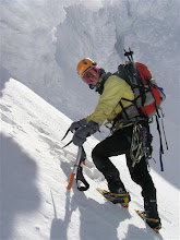
Oh – I have written up some of my summer climbs, but they’ve all been written as trip reports, or discussions on www.CascadeClimbers.com, so written for consumption by mountaineers. If you’d care to take a gander at them, they’re at: Failed Glacier Peak climb, Steel Cliff Route up Mt. Hood, and the last response on Adams Glacier route up Mt. Adams. This last climb was one of my favorites this summer, since it was technical, involved a lot of route-finding through the crevasses, with no assurance of success, and had fabulous weather. My partner was also able to take what I thought was a great picture of me on a snow bridge, in the middle of a huge crevasse in what we were hoping was a route out of the crevasse field:

(can't seem to bring this photo in, for some reason - have to figure it out, later. meanwhile, it's at this location)

Looking forward to touching the, and my, 7th continent,
leora

Thursday, July 07, 2011

A couple of trip reports

These trip reports were designed for mountaineers, but I thought that I'd put links to them, here, since some folks might be interested in reading them.

This one is about a less-often done route up Mt. Hood, Steel Cliff:
http://cascadeclimbers.com/forum/ubbthreads.php?ubb=showflat&Number=1023692

And this one is about a failed attempt at a mountain in the Northern Cascades, Glacier Peak:
http://cascadeclimbers.com/forum/ubbthreads.php/topics/1025177/What_should_have_been_a_Glacie#Post1025177

Safe travels. . .

leora

Sunday, June 19, 2011

The Universe Delivers

Many times, I feel just plain lucky. I choose to say something, and discover something helpful. I’d like to think that those times outweigh all of the times I choose to say something that I later regret. . . This missive is about one of the fortunate times.

One of the guys at work, Matt, was having a devil of a time trying to get an opportunity to climb our local, highest mountain in Oregon, Mt. Hood. He took the local mountaineering group’s basic mountaineering class (something I’ve helped to teach in the past), and signed up for a climb. I was going up every weekend to either climb or teach, and he was maybe climbing to the top of the Palmer snowfield (which is really the start of the significant climbing of Mt. Hood), and turning around and going home, or his climb was being cancelled for one reason or another before even getting to the mountain. 2 weekends ago, I was trying to get someone to climb a technical route with me, and failed, so I asked Matt if he wanted to accompany me for a south side ascent (the most climbed route). He jumped at it. We had great weather, including high clouds that kept the sun off of the top of the mountain until we could get up there, thus avoiding the dangers of ice falling down onto us.

Here are a couple of shots of the sunrise:


And:

That’s Mt. Jefferson peaking out through the cloud mass that the sun is lighting up.

We were successful and had just stunning views of all of the surrounding mountains, and the cloud shrouded valleys, below. We headed down, and got to a safe spot, the Hogsback. Matt was telling me how beat he was. He ate, and I suggested that perhaps a snooze was in order, as soon as we got to the base of Crater Rock, out of the way of any possible avalanche, ice, or rockfall danger, since the sun was blazing at this point. We went down to the base, and tried to snooze for about an hour. We then headed down, with Matt telling me that he was having a splitting headache, and no amount of water seemed to get rid of it. As we got down to the top of Palmer, with 2 miles and about 2,200ft in elevation still to go, he told me that a migraine was coming on, and that he wanted to put a wet towel on his head and sleep in the dark, but all we had was bright sunshine and a ways to go. I started to wonder if there was *anything* that I could do to help him. I realized that I could take his backpack, and then he would just have to worry about getting his body down. I took his pack, and strapped it on my front. He’s a tall guy, so it stuck up a bit, but wasn’t really much of a problem – with all of the water he’d drunk, it was pretty light. We kept going down. With a little over a mile to go, and still another 1000ft left to drop, we came across two guys taking a lot of pictures. One of them turned to us with that “can you take a picture for us” look in his eyes and he may even have asked it, aloud, and I answered him, that of course I’d be happy to do so. I took their picture with the top of the mountain behind them. They started asking questions about what we’d done, and I was answering. Matt was suffering. We turned around to go down, as did they, but they were still behind us. I decided that I wanted to know where they were from, since they’d been speaking another language when we’d approached, and were obviously tourists. I yelled back the question about where they were from, and they called back “Israel.” I’ve been there, years ago, and despite having relatives there, which should make it more attractive to me, just didn’t care for the heat. Just like Florida, I have a hard time returning, and have yet to. I told them about that, and then mentioned that we have a team of Israelis whom we work with at my company. I so rarely mention what company I work for. I don’t know why – perhaps because many people, in places I’ve visited, give me a blank stare when I do . . . This time, I thought, let me just mention the company. I told them that I work for Intel. They both piped up, “me too!”

We started chatting about all of the people we know, quickly establishing that we knew some of the same people. And, finally, we got around to exchanging our own names. One of the guys, Muhammad, offered to reduce my burden by taking Matt’s backpack from me. He was happy, because he felt like a mountaineer, and I was happy, because it was easier to see without it. As we continued down, I started thinking about the ride home. I’d not gotten any sleep the prior night. I’d woken up at around 6am on Friday, worked all day, and tried to sleep at a colleague’s place, but was never successful before having to pick up Matt at 10pm, and starting our climb at midnight. At this point, it was nearly 3pm the next day, so I’d had 33 hours of no sleep. I told Matt that I was sorry, but I would have to sleep some before I would be able to drive home, so his agony would continue, since for sure, he was not able to drive. Steed, the other Israeli, piped up that he and Muhammad could help drive. At first, I thought that this sounded impossible, but then I realized that they would have just 1 car between them, and could split up, with one driving me, and the other Matt, since likely, they would be staying somewhere on my way home. I asked if they could drive a manual transmission. Of course, they could – they didn’t grow up in the US, where automatic transmissions are the norm!

So, when we got to the parking lot, we moved Matt’s stuff into Steed and Muhammad’s car, so that Muhammad could take Matt home, and Steed took over the driving of my car. As I curled up to go to sleep in my car, with Steed driving, I thought of my friend Mary and what she would say to this, “you had a complete stranger drive your car while you slept!!!!! Are you crazy??!?!? “ I told Steed about this thought as I went off to sleep, and his only comment was “I never did show you my badge!” (He was referring to the Intel badge that we all get as proof of our employment.) He dropped himself off at his hotel in Portland, and by then I’d had enough sleep that I could make the 3/4s hour drive back home without incident.

Steed and I wound up going hiking the following day with one of my interns, with Steed driving his rental car. We returned really late, and Steed got tired while driving, so I took the wheel (fortunately, any Intel employee can drive an Intel employee rented vehicle), and as I did so, mentioned that I was happy to be able to repay the favor from the previous day!

Here’s a picture of me from after that hike, with Coldwater Lake behind me, and some of the low mountains north of Mt. St. Helens:


I’m still amazed at how well this all worked out. Oh, and Matt recovered, nicely – just slept the whole way home, and then that night, and felt quite fine, and very happy that he’d climbed his first mountain, and Mt. Hood, at that.

May the universe put out friendly tentacles, at just the right time for you, too.

leora

Thursday, May 12, 2011

The Good, the Bad, and the Tragic

The good news is that my travel buddy and I are going to celebrate his 11/11/11 birthday by traveling to Antarctica!!! We'll be flying to Buenos Aires, Argentina, and then on to Ushuaia, at the very southern tip of Argentina, where we'll hop on a boat, take off across the dreaded Drake Passage (everyone tells me that it's very rough!), visit a sort of arm of land that projects out from the continent, called the Antarctic Penninsula, do some kayaking, and, if the weather permits, an overnight campout on the continent, a little more kayaking, and then return back to Ushuaia. We'll be on a ship called the One Ocean Navigator (also known as Akademik Ioffe) and get to spend about 6 days wandering around the Antarctic Peninsula.

The bad news is that we've had to postpone the Denali expedition until next year, due to Candi's back injury. She's spending the year getting her back up to snuff. Meanwhile, Tom and David are climbing Denali, now, as I write this, with a guide service. Candi, Oleg, and I are currently planning to climb Denali as a threesome, with which Candi is now comfortable. This makes the planning, skills practicing, communications, and likely the whole climb much simpler. It does narrow the safety margin a bit, so practicing together will become even more critical. We did a navigation practice several weekends ago, climbing Mt. St. Helens in a whiteout, which was really fun. There was only one other team on the mountain. I put some wands in on the way up, and we took compass bearings and made a mental note of the altitude of each wand. There was one wand in particular, in the middle of a vast snowfield, that I never expected to see again, on the way down, because we spaced them so far apart, so that relatively vague readings on the compass would get us near, but perhaps not near enough, in such whiteout conditions, to make out a wand, but we found them all, which was quite gratifying.

Our summit shot gives some indication of the low visibility:

Can you see the edge of the crater rim behind me? I sure can't! And in case you can't tell, I'm the one standing, and Candi is sitting.

Now, compare the above to what it looked like on a clear day, earlier in the year, when I went with my friends Rita and Gil:


This was taken looking east, where you can see the edge of the rim in the near distance, and Mt. Adams in the far distance. (JM stands for "Juvenile Myositis.")

The tragic news is that my wonderful next door neighbor, Steve Allen, was killed, yesterday, in an explosion of something called an hydraulic accumulator that he was working on at his work place, Stimson Lumber. It was apparently under pressure, when it wasn't expected to be. This was the neighbor of whom I wrote in an earlier leoralore, when I was having my water difficulties. Steve didn't like to hear about my climbing exploits, because they made him too nervous. . . Little did we know, when we discussed my climbing, that his work would wind up being so deadly. He was a truly wonderful man. He touched many lives, and always in such positive ways. It's heart-wrenching to have to talk about him in the past tense.

Please, all - stay healthy and alive.

leora


Monday, January 17, 2011

Denali: Background and Another Snow Session

By the comments and questions I received, I realized that I didn’t set up my Denali Planning leoralore very well. . . I got the most “grief” from my uncle who told me of his surprise that I would be “climbing” a Denali (Chevrolet Sports Utility Vehicle) or an Expedition (a Ford SUV). Although he was kidding me, I went back and read that missive and noticed that not once did I ever refer to it as a mountain! So, let me introduce Denali, properly!

Denali is also known as Mt. McKinley. It’s located in Alaska, and it’s the tallest mountain in North America at 20,320 feet (6193 meters). Being the tallest, it’s also a magnet for people all over the world who want to summit the tallest mountains on each continent. So, there will be a lot of us on the mountain. . . For us, the plan is to start our trip sometime in May of 2011, and finish sometime in June, reserving an entire 4 weeks to do the trip, including taking all of the flights. The expedition starts at 7,200ft (2195m) on the Kahiltna Glacier, where we’ll be dropped off by a small plane that has us and our gear. We then plan on climbing the 15 miles (24 kilometers), with about 13,120ft (4000m) elevation gain, to the summit via the most common route, the West Buttress. If we’re lucky, the entire time on the mountain will be around 16 days, but if there are storms or what not, it could take longer, hence the reservation of 4 weeks. . .

So, that’s the background information. In November, we did a snow session practice on Mt. Hood with four of the six of us. Both Oleg and Tom were on international trips, so couldn’t join us. Candi and I went on snow shoes, and Denis and David went on skis.

Here is Candi gearing up. Her and my snowshoes are at her feet, and she’s putting the finishing touches on getting her backpack ready, while mine is lying behind her:

Denis and David were able to hustle up much faster than Candi and I were:

Candi is the obvious person in the picture, and Denis and David are the two dots dead center in the picture, near one of the ski lift pylons. Our visibility came and went throughout the afternoon. Mostly, it went. . . However, it cleared up as we set up camp, giving spectacular sunset views:

And the top of the mountain became visible:

Soon after this picture (that’s the back of Candi’s head), we had dug out platforms in the snow for our tents, tied them down, and had gotten started melting snow for water, when the moon came up in the east and the sun went down in the west at the same time! I took pictures, but they didn’t come out, well, so imagination is probably better than lousy pictures. . .

With the weather looking so great, and the snowpack looking pretty great, we decided to try to make it to the summit the next day. We were camped at about 8,650ft, which seemed so low to me, that I didn’t bother to make sure that I was properly hydrated. I just wanted to get to bed and make sure that I got enough sleep before attempting to climb early (5am) the next morning (everyone wanted to get back home, early, so we had to get up early to do the climb to make it back down in time).

Both Denis and David woke up before 1am and took in the fact that there was a full moon and clear skies. They also noted that it was quite cold, but knew that it wouldn’t get much warmer and decided to make the move to summit, then, instead of going back to sleep to get up at the previously agreed upon time. I was feeling like crap, so I was thinking more sleep would be nice, but I had been cold (a 40-below sleeping bag just doesn’t seem to do it for me, unless I also have an inner bag!) all night, and didn’t think that it would get much better, so, yeah, what the hey – I decided to give it a shot, then, too. Candi agreed. We all started up, and I was as slow as molasses. Candi stayed back with me, and Denis and David skied steadily up and out of sight. When I got to around 9600ft (2926m), I threw up! I thought of Joe, who’d gotten ill just around this elevation a couple of years ago, and the 3 of us who were climbing “with” him, not noticing and trundling on up. . . At the time, I couldn’t believe that he’d gotten Acute Mountain Sickness (AMS) at such a low elevation – yes, it’s certainly POSSIBLE, but I’d never known anyone who did – at LEAST make it to 10,000 ft (3048m) before succumbing to AMS if you want to call yourself a climber, for Pete’s sake!!!! Anyway, here I was at 9600ft, and retching. I was pretty sure that there was nothing that I could do to make myself better enough to keep climbing, so I called up to Candi and told her that I was turning around. She told me she’d join me, even though she was feeling very strong. I ran down about 100ft just because I thought it would help me not to retch, anymore, and used my cell phone to leave David a message that we were turning around (fortunately, the cell phone SOMEtimes works on the south side, and it appeared to be working, then). I had no more AMS issues, and by the time Candi and I arrived back at camp, the sun was rising:

We took a “Cure JM” (Cure Juvenile Myositis – the disease for which we are hoping to raise research funds with the Denali climb) picture to the east. Yes, that’s a sea of clouds, below us, in the distance behind Candi. And Candi is quite bundled up because we judged it to be around 14F (-10C), or possibly colder.

The guys turned around at the Hogsback due to super-deep snow, and met us just as Candi and I were leaving camp. Since their trip down was going to be faster on skis, we took off, doing some gear exchange with them when they passed us on their way down.

As a practice session, it wasn’t the best, since we pretty much didn’t practice anything that we would need to do on Denali, except deal with cold and melt snow for water. If I needed a reminder, which, apparently, I did, that hydration is important, I definitely got it. But it was ok that we didn’t practice any of the other stuff that we’d need to do on Denali, since we intended to have other sessions later in the 2010 year, and in 2011, including everyone. However, as what happens with expeditions many times, things change. Our December session didn’t happen, because Denis dropped out (an expected change in jobs wasn’t going to be conducive to taking a month off), David and Tom got busy, and Candi sprained her back.

Soon after, David and Tom dropped out, deciding that they would go, instead, with a professionally guided group. This increases the chance of success of the climb, so it’s quite understandable. However, it’s not the type of climb that I’m interested in. I told Candi about this newest development, thinking that she would still insist on 6 people for the team, and I was ready with a bunch of ideas about how to obtain the additional 3, but to my surprise, she’d already thought about just doing a 3 person climb, and was now ok with the idea. Three people climbs are a HECK of a lot easier to arrange, plan, practice for, etc. On the actual climb, we won’t have the added security of having an additional team to help haul out us out of a crevasse, should one of us fall in, and we won’t have as many options if one of us gets ill, but the coordination and preparation, which are a pretty huge part of the expedition, will get much, much easier.

However, Candi still has a sprained back.

So, are we going, or not? Well, we don’t know. We’ve decided to give it until the end of January. If her back is fine at that time, then we will go as originally planned. If it’s not, then we’ll be forced to put off the climb for a year.

There are advantages for me, personally, either way, so I’ll just wait until the end of January for that decision, and meanwhile, continue the planning and getting ready, as if I were to go, since some things need to be done whether it will be this year, or next year.

May your dreams come true!

leora