Friday, March 29, 2013

3-day backcountry ski around Crater Lake


The short version: Rita, Jason, and I did a 3 day 30 mile (48km) backcountry ski trip around the whole of Crater Lake, in Crater Lake National Park (Oregon’s only national park), which included my birthday celebration in the middle of it.  Rita went all out with a card & gift, a birthday napkin, candle, and exceedingly rich little brownie truffle things.  Jason’s picture of us (with Crater Lake as the backdrop) sums it up:
 
The long version:

About a month ago, Rita (climbing partner whom I met in 2010) and I were discussing climbing plans for March, and we’d settled on Mt. Shasta for 3/23-28, when she was free.  Jason (a long time climbing partner of Rita’s, and frequent partner on Rita and my climbs) was also going to be available.  However, on Saturday morning (3/23) before we headed down there, we had a 3-way phone conversation, looking at the weather and avalanche conditions all the way from the Northern Cascades, in Washington, down to Mt. Shasta, in California, and things just weren’t looking good.  Around Crater Lake, though, the weather looked conducive to a trip Rita and I’d talked about doing a year ago: backcountry skiing around the lake.  She’d done it 30 years ago, in two days, and had wanted to do it, again.  Since we had three days, to do it, this time, she threw in a climb teaser for me – Mt. Scott, a 8,929 ft (2,721 m) mountain in the park. 

So, Jason and I packed for an overnight ski trip, rented skis, and drove down to Rita’s that Saturday, and Rita drove us down to Crater Lake National Park on Sunday.  On the way, I was reading various reviews about what we were about to do.  I remember reading something about how anyone can ski on the west rim trail. 

We started off with 40+ pound (18+ kg) packs at around 1pm going in a clockwise fashion:

(click on images to see higher quality versions)
Here we are (Rita, me, Jason), at the start of our journey, with Crater Lake spread out behind us, as we set off from the Rim Village entrance point. 

It seems that I’m not just “anyone”. . .  I managed to fall 3 times just getting from the Rim Village view point to where we were obviously on the road!  We’d had the skis waxed when we picked them up, making them absolutely glide on top of the snow.  This can be a good thing.  For me, though, while I was grappling with trying to get my balance on the skis with this 40+lb bag on my back, a little stickiness might have been a good thing.  This was more like trying to get traction wearing patent leather shoes on a sheet of ice.  Just as I was getting extremely worried about what I’d agreed to do, the more flat snow of the road came before me.  I managed to stay upright for a while, and felt as though this might go as I’d originally expected, rather than as the first 10 minutes had gone. . .  After all, it was just the prior week that Rita and I had gone on a ten mile cross country ski trip, with normal cross country skis (long, skinny skis with no steel edges), whereas, now,  we had backcountry skis (wider, a little shorter, and with edges), so my expectations for this trip, on a snow covered road as a trail, were that this would be a pretty straight-forward trip.  Hah!

With my angst about the first several falls waning, I was again able to marvel about the beauty that surrounded us.  One of our jaw dropping views, with Wizard Island in the forefront:

And another:

Mt. Scott is the tallest peak in this shot.

More beauty with Rita and Jason standing checking out the view:


I like the following shot because it gives some indication that there were a bunch of others (and some “anyone”s who could actually ski) out there with us at this point in the trail, as well as having stunningly beautiful scenery, nearly perfect mirroring of the rim in the water, and Jason center picture:


As in the above picture, there was, thankfully, a lot of smooth, flat, and wide snow surfaces to ski on.  What I didn’t capture were some of the more hair-raising surfaces.  Fortunately, Jason was a little bit more on the ball, and did try to capture some of it.  In this shot, I think that you maybe can get a sense of the narrow top that we sometimes wound up skiing along, with a huge drop off on at least one side (in this picture there is probably a 1000 foot (300 meters) drop off to the left, which was quite scary, especially when I couldn’t seem to make the edges cut into the icy crusty surface of the snow, and the skis would sort of slide in the drop off's direction: 


The minor drop off to the right was not a big worry to me in the above picture, although it sometimes got pretty darned deep, as you can tell, perhaps, from Jason’s picture of me from one time when I decided to ski down into the gully on the right rather than on the narrow tippy top:


In Rita’s picture of Jason and me, below, there is a cut-out in the snow just near where the two of us are headed – that was one scary little crossing, as that cut-out looked straight down 1000 feet (300 meters) to the water.  Great, I thought, if I fall to the right, it will be a fall into the water, and certain death, or, if I fall to the left, it will be a nice lengthy sliding fall, likely ending in death, but not certain death:

Needless to say, I was rather relieved when I passed all of these potential disaster areas unscathed.  And they were actually mere fractions of the entire skiing experience, even though I’m magnifying them, here, by mentioning them, and in such detail!  

So, to continue in this vein just a bit more, there was one hill that I thought that I could get through, and skied down it, and was busy congratulating myself on not falling on the steepest part of the descent, when one of my skis caught on a little block of ice or something, causing the ski to stay behind just a bit, which, with the big pack, caused my body to lurch forward (or, more precisely, my body maintained its speed, while the skis did not), and I did a spectacular face plant.  At least, that’s what one of the team of folks watching me fall told Rita, while chatting with her. . .

Rita was wearing a GPS watch, and was keeping track of our progress.  It was rather slow.  After only 6 miles (9.7km), we were starting to be pretty ready to look for a camp.  We were at the junction to the northern entry, where snowmobiles can come zooming in for a look at the lake, and then zoom back out.  None of us were interested in camping, there, so we pushed on, and finally found a nice spot about 7 or 7.5 miles (11 or 12 km) in from the start.  We started to re-assess our general plan – Mt. Scott was out.  We judged that we could still make it out on the third day, if we could make it at least 12 miles (19km) the 2nd day, which seemed reasonable, as we would be starting out to ski much earlier in the day.

Before heading to bed, I spied the sunset, which Jason managed to capture with his camera:


The next day I was greeted at the entrance of our latrine by crepe paper, courtesy of Rita:

I assumed that that would be the end of the celebration, but, as the first picture in this write-up, shows, yes, there was more. 

Incidentally, in that first picture, if you look between our heads, it was at that part of the shore that we embarked on the trip.  We were slightly more than ½ around the Crater’s rim, but not anywhere near ½ of the mileage needed to get back.   We re-assessed, again, at the birthday celebration time, and started thinking that another day might be necessary.  Rita was able to get a cell signal and texted her husband to let him know that things were fine, we just might need more time.  The next bit of the trail was all about getting to the base of the trail to Mt. Scott, which meant that we had a steady uphill.  We would see Mt. Scott in the distance, and see a bend in the trail and think “yes! Just around this bend, and we’re there!” and then we’d get to that bend, and see that we still had to ski up another big hill.   I think that that happened about 3 times before we got to the top, and near the junction.  When we did, we were greeted with a wind-swept snow landscape.  Rita, studess that she is (besides being a much better skier than either Jason or me, she is also in much better shape), was waiting for us at the top.  We looked around and saw thick clouds moving in.  We were tired and needed to rest a bit, so we continued on to find a little bit of shelter.  Almost immediately, there was a little drift of snow, and a downhill.  I started down it, and promptly fell over.  Jason, coming up behind me, asked me if this was where I wanted to stop for the rest, and then realized what had happened, saying something about it being an impromptu stop.  Rita, coming up behind him, also was worried that I was choosing that spot to rest, and then, too, understood, when she heard Jason’s comment.  We continued on and found a section of the road, showing, with the sun shining on it.  I had some hot spots on my feet that I wanted to tape, so that I wouldn’t get blisters, so I attended to that, we all ate, and rested just a bit, but the wind picked up, the sun got blocked, and we started to think that maybe the weather system predicted for the next day was coming in, early, so we decided that we needed to find a nice camping place out of the wind, and much lower down.  While it was tempting, in theory, to have a nice downhill at the start of the day, at night, an icy crust forms on the snow, if it’s cold enough (and it was), which meant that we’d pretty much be skiing down ice in the morning (if it didn’t snow that night).  So we opted to do the downhill and get back down into the trees with their protection from the wind.

We found a lovely place to camp:

Rita is standing in her nicely created kitchen, with our seating area on one side, and cooking shelf behind her, complete with a wind break. 

And then it snowed that night.  A couple of inches, which was funny, because before we went to bed, Rita said that her hope was that we’d get a couple of inches of snow, so that the skiing would be better.  She got her wish (you’d think that SHE was the one who blew out that birthday candle!)! 

When we started out in the morning at around 10am, we noticed that the snow was sticking to our skis, so we stopped to put on wax.  While we were doing so, the other party we’d been leapfrogging, passed us, after having camped near the high point.  They’d started out at 8am in a whiteout and with the new snow, which made their route-finding very challenging (they couldn’t just follow other people’s ski tracks), and they finally made it to us 2 hours later, on an area that took us about ½ hour to cover the previous evening.  We were even happier with our choice to camp down low.

As we continued around, we approached one of our decision points.  One way led to a known avalanche area, and the other was the avalanche by-pass, which meant that it would add mileage.  With the state of the snow pack, the added 2 inches of snow wasn’t of particular worry to me, but it seemed that most of the others had taken the bypass, we couldn’t see what we’d be getting into, and Rita figured that she’d rather go longer and be alive then shorter, and perhaps get into a little trouble.  She’s so sensible. . .  We took the by-pass. 

The by-pass took us down a lower road that was near the bottom of the avalanche run out.  Had it been a high snow year, and high avalanche danger, I’m not so sure that I would have been very happy with this routing.  As it was, we got to see the new avalanche debris from the prior day’s avalanche (when it was all warm and sunny).  We saw that several people who’d elected to go on that upper road skied down out of it.  As we looked up at where we would have had to ski, Jason commented that avalanche zone or not, he was glad that we weren’t skiing up there, and I agreed!  It was a narrow place.

The detour that was taking us down this lower road abruptly headed onto a blue (typically meaning “intermediate”) trail.  I was remembering the blue trail Rita and I had been on the previous week, and was thinking that I didn’t want to be on another one with a heavy pack.  Rita was non-plussed and pointed out to me that it would be uphill – heck, *anyone* can ski uphill (no, she didn’t say *that* - I’m just interpreting. . .).  So, we took off up the hill, and it wasn’t too bad.  Jason and Rita had to stop for a clothing break, but I was still chilled, so I wanted to continue on and get warmed up.  I was soon sidestepping in very steep, treed terrain.  It warmed me up, for sure, so I took off a layer or two and waited for Rita and Jason to catch up and we all commented on this trail that none of us could imagine skiing *down*.  As I continued up, and it got steeper, and the snow surface a bit crustier, I started to notice that someone had walked up it, which was becoming very appealing to me – I was thinking that I could make quicker progress without the skis than with, since I was having to side-step the whole way.  Just then, I slipped on the crusty ice and fell.  I used it as an opportunity to take off my skis and start climbing.  I hollered to Rita and Jason so that they’d know I’d made that decision.  It turned out to be much easier for me, especially since someone else had already done the work of making steps, and because it appeared that more and more people had made the same decision to start walking, so the steps were getting pretty solid.  Still, I wasn’t sure that they’d be good enough steps for Jason, because he is so much heavier than I am, and I was afraid that he might still post-hole (punch through the step and further into the snow, which is very, very tiring) so I was feeling sorry for him as I trundled up the hill. 

I eventually made it to a place where I could put my skis back on, and was hoping that I was just about at where the road was so that I could shout down encouraging words to the others.  Unfortunately, I saw that the trail went on, with the road no where in sight, so just yelled down that I was able to put my skis back on (indicating better terrain), but that we hadn’t arrived.  Rita had also shed her skis coming up.  Jason was a hold-out, but did try walking for a little while, and did have the problem of punching through the steps, so that hill was even more strenuous for him than it was for us.  It’s a good thing that he’s a strong guy!!! 

We were hoping to get to the road before taking a break for lunch, but as we continued on the trail, it became obvious that the road was *much* farther on, and would be in a much windier spot, so Rita, reading my mind, chose to hunker down in a sheltered place to eat lunch.  As we did, we marveled that a group we’d seen going counter-clockwise around the lake with a sled had made it down that same hill without injury!

There were two more avalanche zones that were on the trail (and two more by-passes for those zones), but at that point we were going downhill, we could *see* the avalanche prone terrain ahead of time, and the road through them was nowhere near as scary as the first one, and the avalanche danger continued to seem low (we weren’t getting blasted with the sun), so we just skied right through them.  Well, Rita and I skied through them.  On the second one, Jason stopped in the middle and started taking pictures, so Rita and I started yelling at him.  “What?”  “Avalanche zone!”  I think that he may have replied something like “Oh, so I shouldn’t be stopped here taking pictures?”  He likely was in no danger, but it’s sort of nice not to tempt fate. . .

Just around this time, we started to realize that we *would*make it out that day, and not have to spend another night, as we’d come to expect.  The long downhills had allowed us to burn a lot of miles rather quickly.  We even started saying silly things like, gee, wouldn’t it have been nice to have had our ice tools and climbing gear so that we could have climbed this frozen waterfall, pictured, below?


Alas, we had no desire to have heavier packs, and were rather thankful that we were able to make it, and on our original 3-day schedule.

I think that I’ll leave you with one of our lake views on the last day, with the low hanging clouds and the instigator of this glorious trip:


May you have such instigators in your life!

leora


Tuesday, March 05, 2013

Trip Statistics & Florida wildlife


I recently returned from my extensive friends and family visiting trip around the US.  I’ve been remiss in keeping people up to date via my leoralore list and this blog, so thought I’d start with a short piece that relays some of the statistics I’ve accumulated about the trip, and do some shorter write-ups about various aspects of the trip that were “story-worthy," later.

Over the entire trip, I:
  • drove 14,764 miles (23,760 kilometers)
  • visited 35 states (other than Oregon)
  • visited the 8 continental states I’d never visited before: West Virginia, Alabama, Mississippi, Arkansas, Oklahoma, Kansas, New Mexico, Nebraska
  • was gone nearly 6 months, 3 of which were spent in Michigan
  • slept in 36 different beds, only one of which was paid accommodation (when ice climbing in Ouray) [a HEARTY thank you to everyone who put me up on this trip!!!!]
  • arranged to meet some 76 different families/individuals/groups
  • did NOT get around to seeing some 18 individuals/families/groups I’d intended to visit when I started out on my trip!
  • spent (only!) 8 nights camping out
  • spent 1 night sleeping (fitfully) in the car (across the 2 front seats)
  • took over 2000 pictures (mostly with the people whom I visited, and photos for Cure JM)
So, I’ve now been to 49 out of our 50 states, with my last state being Hawaii, although, I have, in point of fact “been” there, as I had a stopover in the Honolulu airport, although I don’t like to count that, and I do wish to visit the state.

One nice thing on this trip was that I got to visit the Big Cypress Natural Preserve, in Florida along the Tamiami (pronounced Tammy-ammy) highway.  This was made possible by a relative of a friend opening up her house to me in the Miami area, so that I could shoot across the southern part of the state the next day to visit a cousin on the western side of the state.  I was very much impressed, first with the highway, which was very straight, and typically had water on both sides, but also with trees and the tons of birds hanging out in the trees and along the edges of the water.  When I got to the Big Cypress Visitor Center, I understood why.  The water along the side of the highway was chock full of fish!   As well, the water was chock full of alligators!!  I never saw the alligators appear to eat anything, and only once saw a bird get a fish.  But the fish, alligators, and birds were all plentiful!

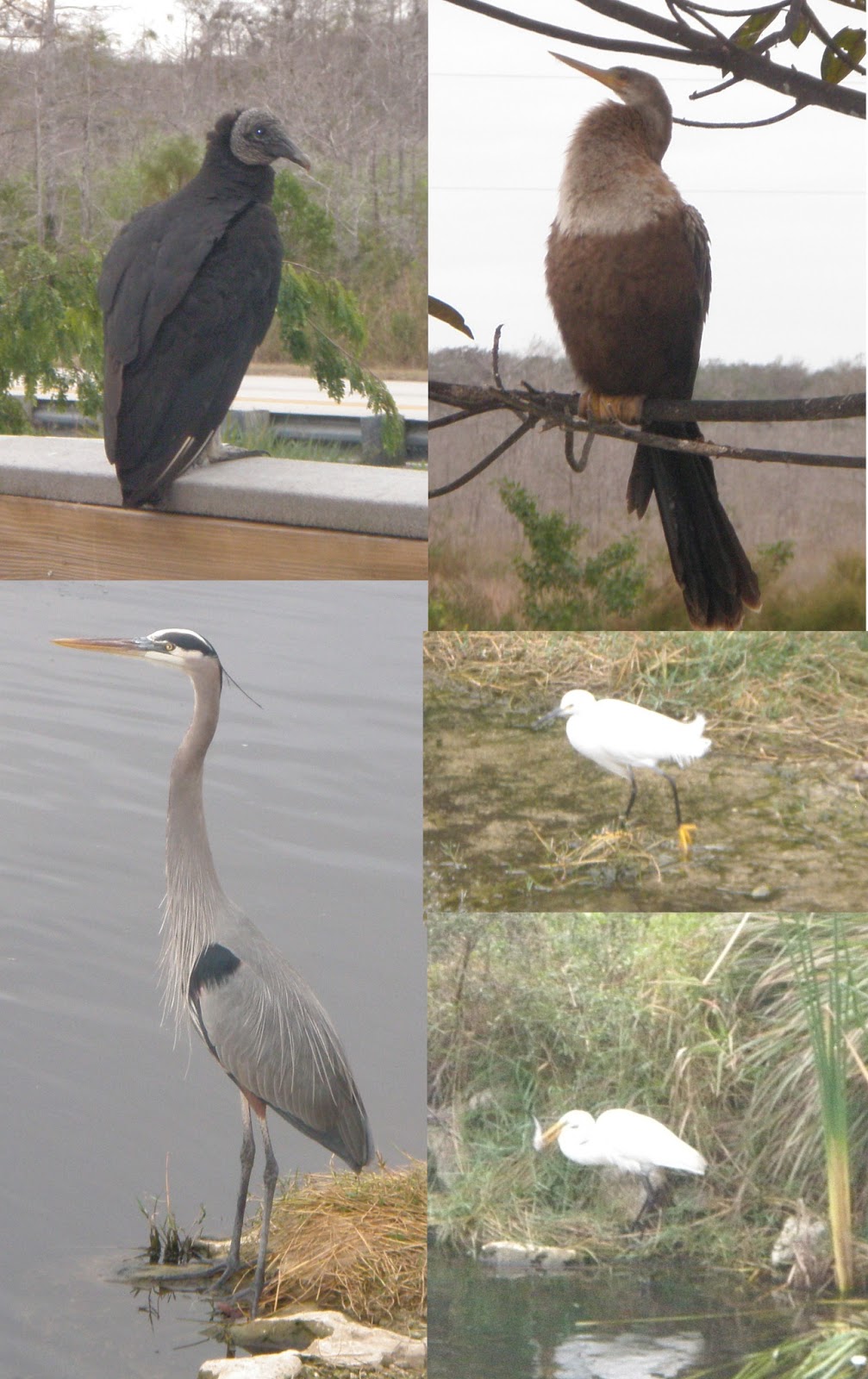
Here is a sampling of the birds I saw, there:
Clockwise, from upper left: black vulture, anhinga, an-I-don't-know-what, egret (with a fish in its mouth), great blue heron.

And here’s a bunch of fish – I think that that may be an alligator head on the right:

And one of the many alligators that I saw:
I like the above picture, because you can see the whole alligator, but I like the below picture, because the eyes are so classic:

Here is a typical bird and alligator picture:
At one of the rest stops in Florida, I saw yet another heron, this time, with a ton of turtles:
There are no fewer than 7 turtles in the above picture!!!

Finally, here is one of me, hanging out with a bunch of brown pelicans near Boynton Beach, Florida:

While I’m not big on Florida, I was happy to see even that small section of the Big Cypress Preserve and all of the birds that were present in Florida, in general.

May you always have a nice place to sleep!

Leora


Sunday, September 16, 2012

Oregon to Michigan highlights (lots of pictures!)

On August 25, 2012, I started my approximately 2,500mile (4,000km) trip out to Michigan, where I expect to stay for the next couple of months.  Here are a few of the highlights of that trip, which lasted a week.
 

In earlier trips out through this part of Washington (US 97 crossing from Oregon into Washington), I think that I was blithely unaware that this replica of size and form of the English Stonehenge existed.  It makes me want to get a clue as to how it could be used to measure time and mark seasons.  It was the first monument in the US for those who gave their lives in World War I.  It looks pretty crappy in the picture – there was lovely scenery all around it  (except on this side), except that I couldn’t get a picture of the whole thing from any of the other more flattering sides.  I see that others managed to get a better picture at website for Stonehenge. (Click on the pictures to see a higher quality version of them.)

Dotting this whole area of Washington near the US97 crossing of the Columbia River, are windmills.  I have to admit, I thought that they made for a pretty picture:

I didn’t tarry too long in Washington, except for Stonehenge, taking a few pictures of windmills, and waiting for our chance on the single lane in a construction zone.  By the time I got to Coeur D’Alene, I knew I needed to bed down for the night, so I started looking at possibilities as soon as I got within National Forest boundaries.  I found a place that was unfortunately above Interstate 90, so I heard the gentle roar all night, there, but as it was after dark by the time I started looking for a place, I decided to settle for it.  So here is a picture of where I slept that night:
In the dark, it seemed to be out of the way.  So, it was amusing to be awakened by a guy and his dog hiking by me in the morning.  Since someone was using this as a hiking path, I decided that that likely meant that I could get a good run in, here, so I went for a run.  It was quite nice, indeed – with lots of views of treed low mountains.  I never saw the guy and his dog while running, and by the time that I returned to my car, his car was gone.  The whole time I was there, no one else came.  I was struck by how nice it must be for the residents of Coeur d’Alene to have such a big recreational area.
 

On the highway in Montana, I was going up a hill and around a curve, when I saw a guy flagging down traffic.  I slowed down, and saw someone walking in the middle of the road, as well – I asked him what the issue was, and he said that there was a semi down, but that small cars might be able to get around it.  I had my iphone on the dash of my car, so I used it to snap this photo as I lined up to get by the truck, passing other semis and RVs who would not be able to get around it:
As I went around the end, I worried about the woman who was standing next to the tail end of it, should it have fallen.  The west bound traffic was completely stopped.  I hope and expect that all occupants of the semi were ok, but it must have been one scary ride for them.
 

After visiting my friends in Helena, Montana, I saw farm after farm after farm with bales of hay.  Here’s an artsie shot of one such farm field:
 
The western part of North Dakota was different in one very significant way – here, the hay fields were interspersed with oil wells.  (See the oil pump in the background of this photo?)
 
The configuration in the picture, below, was duplicated many times over, all over this northwestern section of North Dakota:
 
There were bigger operations, like this one, that also had a lot of rectangular containers, and the flame, burning off the gas: 
 
When I drove into North Dakota, I thought that I was going to drive into the western entrance of the North Unit of Theodore Roosevelt National Park.  However, the roads didn’t seem to match either my Microsoft Streets’ mapping program, nor the Map program on my iphone.  It was starting to get dark, and I was seeing just one oil operation after another, all lit up, and dead end streets.  I decided that I wasn’t going to get to the park that night, so needed to find a place to bed down for the night.  I saw something that looked like a tractor road, and turned into that, which went up a tiny little hill and then down, again, which was enough to hide my car from immediate visibility from the road.  I parked the car, got out, and noticed some deer standing there, wondering what to do.  They decided to take off.  I spent the night, sleeping behind my car.  During the night, some coyotes were checking out an area not far enough away from me (for my liking).  I was happy when a flash from my flashlight sent them running, since I wasn’t eager for a pack of coyotes to think that I might be a tasty morsel.  In the morning, I took a picture of my surroundings: 
The coyotes had been just to the right of the silos in the above picture. 
 

After bedding down for the night, I was able to get a cell phone signal, and so I sent my little “I’m safe” email to my Mom, since I knew she was worrying about me, and told her that I couldn’t find the western entrance to the park.  She thought that was weird, and checked out the park’s website, and discovered that the road didn’t go through (the website said that it was closed at some point – I don’t think that it actually said that there was no western entrance), and emailed me that info, so in the morning, I just looked for a way to go east to get to that entrance, so that I didn’t have to drive 20 miles north to get to the main highway before heading east, and then south, again to get to the park.  The roads had changed from all of the mapping software, and looked as though they were dictated by where there was oil.  I finally decided, when yet another road I was on dead-ended into an oil operation, to just follow a truck carrying oil out of the operation.  That truck, did, indeed, lead me out to a road that led to a main highway. 
 

The roads reminded me of the maze of roads that sprang up behind my house in Tillamook State forest when they started logging operations, there, recently.  In North Dakota, it was obvious that the high quality dirt roads were put in fairly recently, to allow access to the oil operations springing up, everywhere.  I was also amused when I saw a truck repair “shop” out in the middle of nowhere. 
 

I made it to the park fairly early that morning.  As usual, I didn’t want to pay for camping, and it turned out that camping was free if one backpacked and got a permit to do that.  I just had to be ¼ mile off of a trail, and out of sight of both trails and roads, so that my accommodations wouldn’t mar the beauty of the scenery for other park visitors.   The seasonal employee who issued me the permit seemed to think that this was all a big deal.  She made me think that it was, too, even convincing me that a topographical map was required for this grand expedition that I was about to go on.  When I started talking about how I was also going to visit the Little Missouri River, it seemed to me that she thought that it was just too much to do in one day.  And I MUST take at least a gallon of water with me, because there is no water available on any of the trails, and someone died, earlier in the summer due to dehydration.  She made me think that I really was doing something that was a big deal.  Because of that, I decided to go super light, and eat dinner before backpacking to find a place to camp for the night.  I found a picnic area (with running water!), took the little interpretive walk, there, where I took this shot of the park, to give a general feeling of what was there:

The following photo was also taken on that little hike, as well, and has some longhorn cattle (brought back to the area for nostalgic reasons, even though, unlike bison, they aren’t native) lounging in a bend of the Little Missouri River:

It was a wickedly hot day (in the 90s F/mid 30s C), so I decided that I wanted to spend some time in that river.  While I cooked my dinner, a ranger came by, and we discussed my plans.  I told him what the seasonal person had said about the death, and he looked surprised and then said, oh yeah, someone had died in the South Unit, and acted as though that were a whole different world.  He made it seem as though what I was doing was perfectly normal, more as I had originally expected.  But it was still really, really hot, so I took off on the trail that was supposed to cross the river.  The woman who’d given me the permit also mentioned that there was a lot of mud near the river.  She was quite right about that!  At first, I thought that I wasn’t going to have any issues – that I could just walk on top of the crusty surface, and then, all of a sudden, the crusty surface broke, and mud soon encapsulated my feet.  You can see, here, that the mud is over my ankles – it felt as though it would suck my feet down, further – reminded me of stories of the tar pits of prehistoric times:

I eventually made it to the water.  The river was rather shallow, but deep enough in some places where I could lie down in it, getting all of my clothes soaking wet, which I assumed would get all dry fairly soon in the baking heat.  I took a short a hike on the other side of the river, my wet clothes cooling me off, went back to the river, and walked upriver quite a ways before coming back, seeking some shade, and taking this picture from my little place in the shade:
The broken crust was from bison, the longhorn cattle, beavers, and me.
 

I spent a little more time in the river before heading back to the car to finally get ready to go for my hike to find my bed that night.  Just before taking off to go for my hike, I met a ukulele-playing pilot who was using his spare time on his latest assignment for visiting the park.  It turned out that he was doing the same thing I was – just hiking a couple miles in, and camping, so that he wouldn’t have to pay for camping.  As I had originally suspected, it was no big deal, except that he was surprised by an encounter with a rattlesnake his first night out. 
 

With about an hour’s worth of sun left, I finally took off on my evening hike.  My hike took me through “Prairie Dog Town” which was absolutely full of prairie dogs – like these two guys in two of the most classic poses – stretched over the hole, ready to go down it on a moment’s notice, and standing up, looking: 
I also loved the moon coming up while the alpenglow lit up the eastern hills:
There are also a ton of prairie dogs in the above picture, but this version is just too small to see them.
 

At last, I found a nice flat place to bed down.  Here’s my bivvy sack, filled with my sleeping bag and an air mattress in tonight’s bedroom:

I turned around, and noticed that we have our own little “dildo valley” (as I like to call it) here in the US – no need to go to Turkey, except, that no one could build a home in this one:

Soon after going to bed, I first heard the coyotes howling and yapping, and, I assumed, having yummy little prairie dog dinners.  A little later, I heard a swoosh right over my head – I looked up through the netting, and realized that several bats were flying about.  They didn’t hang out very long, there, as the swooshing seemed to stop after just a couple of minutes, so I was able to go to sleep fairly easily. 
 
 
The next morning, I was packing up my gear, and was nearly done when I thought that I could hear the presence of someone else. Sure enough, not 30 feet (~10 meters) away, was a bison:
I remembered all of the stories about how dangerous these animals are, but, there wasn’t much that I could do, so I snapped the above picture of him (I assume that it was a him, since he was alone), and finished packing, so that I could head out of there.  I thought that I would try a short cut, but the bison had moved on, and the short cut took me toward him, so I backed up and gave him extremely wide berth.
 

On my way back through Prairie Dog Town, this little guy let me take a picture of him/her:
So cute!!!!

 
For the rest of my trip, I got to visit a friend in St. Paul, Minnesota, and then I high-tailed it to St. Joseph, Michigan, where I swam in Lake Michigan (ah!  Relief from the heat!), and picked up a high school buddy for our class reunion.  We did stop to check out the historic Kalamazoo Psychiatric Hospital in Kalamazoo, Michigan, where my friend’s Mom had worked, briefly, years before.  It had a nice little tower that we took pictures of – trying to get the Cure JM poster in a Michigan photo, but a security guard came up to us and told us that we had to have permission to take photos of the facility, and told us to delete the pictures we’d taken.  It seems that they don’t want people casing the place, due to some of the folks who are housed there.
 

I hope that you’re all doing well!