For
those who have been following the Mountain Romance, I found my most perfect
mate – a fellow climber (part 1). He proposed on the summit of Mt. Hood,
earlier this year (part 2), and, now, we’ve been wed on the summit of Mt. Hood
(part 3)!
Here
we have the summit photo of the “wedding
party,” also known as the climb team, with puffed rice being thrown, after the
knot was tied (Click on any photo to see them all in higher resolution):
In
strict Left to Right order of the faces: Gary Riggs, Wim Aarts, Candi Cook,
Tomasz Piekarz, Leora Gregory (Bride), Jay Avery (Groom), Jean Hillebrand, Mark
Fowler, Dyanne Foster, Linda Musil, Karen Vernier (Officiant)
After
part 2 of the saga came out, people asked us “when’s the wedding date”?
At the time, we didn’t know, because we’d not gotten that far in our
thinking. Having bought each of us a new pair of lightweight
mountaineering boots to symbolize our engagement (and, of course, for
climbing), we started thinking that a wedding on the summit of Mt. Hood would
be a good idea. We started touting the idea around with our climbing
friends, and our friend, Teresa, whom I credit with “introducing” me to Jay,
let us know that she was an ordained minister. Another friend, Patrice,
proposed that she get ordained through the online process so that she could wed
us. I felt very encouraged by the response we were getting to do such a
wedding.
Soon
after that, I became a climb leader with the Mazamas, the local mountaineering
organization, and I started thinking that it would be neat if I were able to
lead an official Mazama climb as our wedding climb. By mid-February, I
had the climb posted on the public Mazamas’ winter climb schedule, and by the
time we left for a month-long trip to California in March, I had about 25
people signed up for the climb. With so many people signed up
we started wondering how we could get everyone up, and still stay within the
guidelines of the Mazamas and Wilderness Act, which restrict climbs to 12
people, among other restrictions. Jay is a climb leader for another local
mountaineering organization, the Chemeketans, out of Salem, and I was thinking
that if there were too many people who wanted to go on the climb, maybe we
could have him lead a 12 person Chemeketan climb, and I could lead a 12 person
Mazama climb. After Jay and I discussed that possibility for a while, we
finally realized that that was just way too many people to deal with,
potentially creating issues with making sure that the leaders (who have certain
responsibilities when leading a climb) and the minister could make it to the
summit. We settled on having it be a Mazama climb, and that we would figure
out what to do with any additional people, if that really became an
issue.
On
our March California trip, we did some visiting and also climbed to a few more
State High Points (Boundary Peak in Nevada, Mt. Whitney in California, and Humphreys
Peak in Arizona), and finally joined others for some hiking in Death
Valley. In the middle of that trip, one of the potential participants,
Karen, wrote to let me know that she, too, could now perform the
ceremony. That was good news, because, although I was sure that I
wouldn’t need her, there was always this chance that Teresa couldn’t do it,
especially as her knee had been bothering her a lot, lately. When we
returned from California on April 4th, I started looking at weather reports,
told the potential climbers that I was back in town, and asked for people’s
availability for April 8, 10, and 11 (a Wed., Friday, and Saturday), days that
were possible for Teresa to climb. The weather forecasts were all looking
pretty terrible – either heavy snow, high winds, or too high avalanche
danger.
By
Monday, April 6th, I’d seen a report from a climbing buddy that the snow was
hip deep at the Hogsback (a specific place on Mt. Hood at around 10,600ft) on
Saturday. One of the potential climbing participants, Wim, also had been
up on the weekend, and saw a couple of human induced avalanches. This was
just not looking good. Jay and I poured over all of the weather reports,
and I thought that Thursday, the 9th, would be our only option. We called
Wim, and discussed it with him, and decided that, yes, Thursday was our only
weather possibility – another storm was moving in on Friday. I checked
with both Teresa and Karen, and although Teresa wasn’t able to go up that day,
Karen was (thank goodness for backups!), so I sent out mail that night, and by
Tuesday, got all of the responses back, and found that only 12 people could
possibly climb on that day, so no worries about figuring out how to get around
the restrictions on the number of people. After checking weather forecasts
one more time, we sent out the final “it’s a go!” on Wednesday morning, the 8th.
Carpools were then all arranged so as to meet at Timberline (6000ft), the start
of the climb, by 6am, so that we could start the climb at 6:30am. The one
advantage of the current weather pattern was that the freezing level was so
low, that we could do the entire climb during the day, and not have to worry
about the ice on the upper reaches of the mountain, melting and falling on us,
which was a change from the earlier months. It means less disruption to
people’s sleep cycle, and more potential for great views while going both up
and down the mountain.
Wim
offered to ski up ahead, with another participant, Tomasz, assess the
conditions for avy (avalanche) potential, and set up a rope in the most
difficult section of the route, so that people could attach themselves to the
rope, which would then catch them if they should stumble or fall. He told
me that if we couldn’t go to the summit, then we’d just do the ceremony on the
Hogsback. I had to tell him, that no, if we couldn’t go to the
summit, there would be no ceremony – it would have to be done another day,
because we HAD to have it on the summit. It’s just not the same, having
it at some other spot on the mountain! Fortunately, I knew that with Wim,
I didn’t have to worry about that information changing his assessment of the
conditions. If there was high avalanche danger, we wouldn’t be going,
period.
I
had quite a scare when everyone arrived at our meeting spot EXCEPT
Karen!!!! Fortunately, one of the other participants knew that she’d left
late, and therefore would be arriving a little late, due to some confusion at
the carpool meeting place. She arrived shortly, thereafter.
Here’s
everyone getting their packs and gear and avalanche transceivers ready at the
cars:
Packs and gear strewn all
over the place. . . After getting all of the gear together, we all gathered at
the Climber’s Register:
L to R: Mark, Gary, Wim,
tiny bit of Tom, Candi, Leora.
This
is where we fill out the wilderness permit, and the climber’s register, and
discuss last minute details about the climb plan.
Getting
everyone all set and ready to go took a little more time than I’d expected, and
we finally set off around 6:45pm, about 15 minutes late. However, as we
moved up the mountain, we kept pretty good time. Here we are, right at
the start of the climb – the skiers hadn’t started up, yet, but Jay took this picture
of all of the climbers:
Here,
the snow was compacted by snow cats that go up and down the south side of the
mountain, grooming the Palmer Snowfield above us.
In
other places, we were fortunate in that others had preceded us up the mountain,
leaving footsteps that we could use. If we went outside of that
boot-track, we would wallow in a couple feet of snow. Here’s a picture of
me, when I went out of the track to say good bye to Tom, who was having a leg
issue that day, managing to lose my balance while I wallowed. . .:
(Photo
courtesy of Candi) Note that the snow went up nearly to our knees.
Gary and Tom are leaning down to help me up, and Jay is bringing up the rear of
the climb team.
Here
are a few more pictures, from Candi, of the team, as we progressed up the
mountain – you can see what a fabulous day it was – crisp, clear, cool.
This first one has Mt. Jefferson very clearly in the distance (with the 3
sisters and other mountains behind it):
This
next one looks as though we’re coming out of the clouds:
This
one is looking up , with Crater Rock, the center cone of the crater of Mt.
Hood, the most prominent feature:
The
skiers (besides Wim and Tomasz, Candi was also on skis, but stayed with us
walkers) were able to glide, easily, on top of the snow. Skiers put
one-directional “fur” known as “skins” on the bottom of their skis, so that
they can glide up, and the little fibers of the “fur” dig into the snow, and
keep their skis from sliding backwards down the mountain. With their
weight distributed over the whole surface area of their skis they had an easier
time making progress.
Here’s
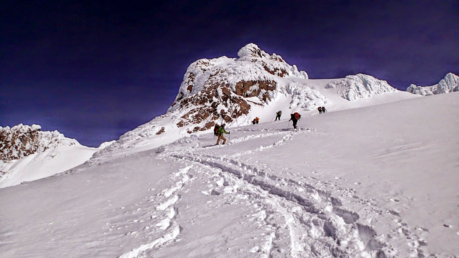
a picture of the team as they progressed farther up the mountain – it’s hard to
tell that Candi is actually on skis – they sort of disappear in the snow:
Candi
is the rightmost person with a red backpack and white boots. There are a
couple of climbers, in the far distance, coming down. Possibly worried about potential ice fall due to the sun-melt, they thought
that it was too late in the day to summit. Since we'd experienced these kind of conditions (low winds, low freezing level, and sun) many times, before, we were pretty sure that we didn't have to worry about sun-melt.
I
love this picture that Candi took of the mountain:
I've taken the above picture and added the route in bright green:

When
we all arrived at the Hogsback, we were greeted by Tomasz, who informed us that
the conditions were fabulous – the Pearly Gates would be mostly a snow climb
(as opposed to an ice climb, as it has been the last several years that we’ve
done it), and Wim was putting in the fixed line. We donned our harnesses
and crampons (the pointy things on the bottom of our boots, because, under all
of that snow, there *was* ice, and we would encounter it on the climb through
the Pearly Gates). Tomasz wanted to leave the ropes on the Hogsback,
which I was fine with doing – we probably wouldn’t need more than 1 rope, and
maximum 2 ropes, and they each had carried up 2 ropes, and 6 pickets – an extra
24 pounds of gear, so that Tomasz’ pack was probably 60 pounds. He was *done*
carrying so much weight. I had to laugh, though – after I agreed to
leaving the ropes, he told me that he WOULD carry another rope up, the rest of
the way, lest Wim think him lazy. . .
And
when I made it up to Wim, the first thing he asked was if we could take the
ropes down with us when we went down, because skiing with the ropes in their
packs was unwieldy. Jay and I readily agreed to taking the ropes down
(for me, that’s the easier direction to carry extra weight!).
So,
the whole team went through the Pearly Gates. Here’s a picture of one of
the team, attached to the fixed line via a small rope to her harness, making
her way up this more narrow passage way. After this, it opens up a bit,
and it’s just another 100 ft or so of elevation gain to the summit:
(photo
courtesy of Candi)
Soon,
the entire team was gathered on the summit, and it was time for the
ceremony. The clouds had swooped in, and the wind was blowing a bit, so
it was pretty cold. I donned my huge parka, and everyone else put on warm
clothes and gloves and mittens for the ceremony. Candi took off her
harness so that her skirt looked more like a skirt. And Mark took out his
tie, that he’d been concealing under multiple layers of clothes on the way
up! They were dressed for the occasion!
People
got out their cameras and got in position for the ceremony, and Jay and I
grasped each other’s heavily gloved hands, and Karen commenced the ceremony (thank you to Tomasz for taking these pictures with Jay's camera!):
I
like the above picture, because it shows Jay thrusting his ice axe into the
snow – we both have them attached with some webbing, to our harnesses, and
although there’s no way that we’re going to fall down the mountain from this
spot – it’s a habit to put the ice axe in to anchor one’s self.
(Although, with so little of the ice axe penetrating the hard packed snow on
the summit, it isn’t much of an anchor. . .) You can also clearly see the
crampons on Jay’s boots (we were both wearing our “engagement boots”!).
Everyone was wearing crampons, but they don’t show up as well on everyone else.
The
following is a little better picture of Karen while she was officiating, and
some of the wedding party in the background – either sitting, or standing,
trying to get a good picture:
I’m
holding 2 bouquets of flowers – one, of Lilacs cut from one of the wedding
party’s lilac bush, and the other, some plastic flowers that held up quite
well. . .
This
is a picture, taken by Candi, of us while Jay was saying his vows:
I
knew that I wouldn’t be able to say any long vows, so mine were to say “me too,”
and I did manage to say those two words, after Jay said his vows.
The
following was our “pre-kiss” after we exchanged our wedding altimeter watches
(where others would have exchanged rings) – it’s hard to see, but they’re in
our hands. We kept kissing, and Karen kept telling us that we couldn’t
kiss, yet, so I called it a "pre-kiss"!
And,
finally: Pronounced husband and wife at 2:20pm:
And
the REAL kiss:
I
had Karen “catch” one of the bouquets, and Candi, the other, and then Karen
brought out the cake that she’d bought at JaCiva Bakery! We cut the cake
and did the feed each other thing, and then the team broke out the
Martinelli’s, discovered that a bottle opener was needed to open it, so used
one end of an ice axe to open it, and then Linda delivered the plastic little
wine glasses. Unfortunately, she sat on some of them, so when she filled
up one glass, it all went spilling out of the stem – cracked me up! We
got 2 that worked, and then we did the hook arms and drink thing. I told
the team that my housemate would be happy that we were doing these traditional
things, because before we went on the climb, she asked me “are you going to do
ANYTHING traditional?” Here, I thought that the fact that we were having
a wedding at all was pretty darned traditional!
We
had sunflower seeds and puffed rice thrown on us (I’m sure that the crows and
ravens will be happy, although, yes, I know we’re not supposed to feed the wild
animals), and we wanted to get a group shot. Fortunately, 3 climbers from
Eugene were on the summit, and one of them took our pictures with a couple of
different cameras. I like the one with the puffed rice in front of us,
the best, so that’s the one at the beginning of this missive.
Then
it was time to get the team going down the mountain. It was fairly
anticlimactic, so we just have a few pictures, courtesy of Candi. Here
she is on the Hogsback, looking back at the route where we are all making our
way down:
I
love the hint of clouds in the picture. They would come and go –
sometimes reducing visibility to about 40 ft!
When
we all got back to the Hogsback, Candi offered to do a reception. The team requested that it be on Saturday,
and, with that settled, the skiers took off. Linda also took off, as she
had to go into work when she got back! The rest of us stuck more or less
together, with the last of us arriving at the parking lot at 7:08pm. Just
a tad over a 12 hour day.
Here
is one final shot, and it is of Tomasz and Wim skiing down below Crater Rock (photo
courtesy of Candi Cook):
And
that is the last picture of the climb. . .
At
the very short notice Saturday reception, JoJo O’Connor took a better picture of us and our wedding
altimeter watches:
Because
we didn’t know when the wedding would be, depending, as it did, on the weather
and climbers’ availability, we couldn’t plan a traditional wedding
reception. We’ve opted, instead, to have a series of little parties to
celebrate, and get friends and family together. We’re having an open
house-style reception at our friend, Rusty’s house on May 2nd, where people can
come and go when they please, in Oregon. We’re having one for our family
in Michigan, this summer, and I’m hoping that we’ll have something *next* year,
on the east coast, likely in New Jersey, when we try and hit all of the eastern
states’ highest points! Feel free to contact me if you are feeling left
out and we’ll figure out how to celebrate!
Links
to videos and pictures:
Video:Linda’s Version of the vows
– with full transcript in the description. This version only has Jay,
Leora, and Karen visible.(Length 4:10)
Pictures: Candi
selected about 35 pictures out of the couple hundred that she took, and put
together a nice little story of the climb. Here are Candi's
public pictures, with captions (Click on the first picture of the album,
and you’ll be able to scroll through the different pictures, with the captions
appearing to the right of the picture).