(This was written for our Ice Climbing class - this was the easiest place for me to put up pictures and commentary that they would have access to. Sorry that it's not readily consumable by all. . .)
This is Adams glacier taken from Divide Camp trail (we didn’t go to the actual “Divide Camp” camping ground, by the way – we, instead, camped near Adams River). On the glacier, there is plenty of water streaming, so no need to bring a lot of water. . .
 This next picture is taken from our camping place, just at sunrise, looking at Adams Glacier:
 This next picture shows the base of the glacier in the distance, as we were approaching. Note that it’s very broad, and the snow ramp up into the glacier comes from the far left, so, of course, we went up the middle of the right hand side – easy ice walking.
 This next one I took because there was an optical illusion, when I was approaching the stream from the bottom, it looked as though it were flowing uphill, because it appeared that I were walking downhill. This picture is taken from the uphill side, looking downhill, and it had the same optical illusion from this direction, where it appeared as though the water should be running toward me, rather than away from me, but it was, in fact, running away from me, since that, in reality, was downhill. . . (doesn't it look as though the top of the picture is uphill?)
 The clouds were finally lifting. After the initial easy glacier walk, we moved to the snow ramp that is just right of dead center of the photo:
 The glacier really started to look spectacular at this point, so even though we were in the middle of a bunch of boulders, which would suggest that they might come tumbling down from above, I stopped to take some pictures – this one looking up as much as possible to the snow ramp we were about to ascend:
 and this one looking northward:
 Ok, at this point, we rejected the snow ramp to the north east, and headed up and to the right, thinking that there was also a snow ramp, there, too. After crossing a crevasse and moving to the right, we saw ice to the right (you’ll see it, better, in the next picture), and the rest of this beautiful stuff (sorry about the sunshine in the lens):
 Here’s the ice wall that we climbed, thinking that on top would be a snow ramp, but instead, were greeted by ice, but at a much, much tamer angle:
 Yeah, I know that this picture is crappy, but it gives some perspective – we were at the top of the ice ramp – just another hundred crevasses left to cross (ok, ok, it wasn’t a hundred, but it was QUITE a few after I thought that we were “almost there!”). You can see the start of the glacier (from a climbing perspective) in this photo:
 And for this one I swung the camera more north-northeast – on the far, far right of the photo, I think that you can maybe make out the north cleaver, beyond the red ridge that is close to us:
 And, I continued to swing the camera to the east – should be almost due east – looking up –that bump above the yellow – I think that that was the top of this ridge. Backtracking, and looking at the map, I’m thinking that I took this picture from 10200ft, and that the top of the ridge was at 11800ft, so a lot more crevasses and ice climbing left to go:
This is pretty much the same picture, but with the perspective of the rock cliff that we were at, just before climbing the rest. . . we followed the edge of the shade up:
 I took no more pictures on the way up - just tried to get my butt up there. . .
 I took no more pictures on the way up - just tried to get my butt up there. . .
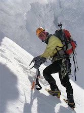
1 comment:
Just google Mt. Adams and see that it is located at Washington state. Camp beside river-side with ice is very special. What if ice come down and flow you away at night? Ha..seems I worry too much.
Post a Comment