Well, I think that we'll survive.
I was forwarded this video url (WHO video) that is about Taiwan not being a member of the World Health Organization, a video published on the Taiwan's Department of Health website in May of this year (unfortunately, the video disappeared from the Department of Health's website, and so the url now points to one that is of lower quality, but does have the same content). This, of course, could spark political controversy, which I'm not really interested in doing in this list, but I did want people to see it, because I am extremely impressed with how well a whole bunch of unique-to-Taiwan images, as well as "Chinese cultural" images, were captured in that video. There are images of native-people-to-Taiwan dancers, a dragon boat race, lantern festival, Chiang Kai Shek memorial, a plane landing at what looks like the Taipei Municipal Airport, someone playing the Erhu (a 2-string instrument, and one that is being played for the music in the video - sounds somewhat like a viola), picking Guava (a very popular fruit, here - maybe by the time I leave, I'll understand why. . .), Taipei 101 (currently the tallest building in the world), the MRT (Mass Rapid Transit system) in Taipei, people showing the peace sign when people are taking their picture (index and middle finger creating a V), the sulphur vents in Yangmingshan Park, the red lanterns that decorate many streets and temple areas, the ocean with that majestic sky - sun streaking through the clouds, the Daoist temples, a big family gathering around a round table with tons of food, people doing exercises in a public park early in the morning, a waterfall with a flowering tree which was taken in TianShan - a snapshot of which I have from when I visited Taiwan 25 years ago for the first time with Jeannie and her then boyfriend, and now husband, David. Hey, the only thing missing in the video is a radar picture of a typhoon covering the island on the zoom-out at the end! (The wind is really picking up as I write this.)
On to hiking, which I've been wanting to talk about for months, now. . .I've been doing a lot of hiking here in Taiwan - various friends and colleagues have taken me hiking to various places, mostly around Taipei (there are several "mountainous" areas around Taipei - YangMingShan Park (Shan means Mountain), and GuanYin Shan), and I was put in touch with an English bloke (pianist) who has written a couple of Taipei area hiking books and who has some regularly scheduled hikes. Going with him (Richard Saunders, in case you're interested in purchasing his books, which come highly recommended by other hikers), has been very interesting, since it was the first time that I'd really gone out with anyone except for the locals, excepting my first week, and times when managers came from the US. People on the hike were from all over the world: Germany, Montreal, South Africa, France, Malaysia, Australia, with mixed abilities in Mandarin. The common language was English. Many of these people had lived all over the world, so it was interesting to hear of their experiences and find out what they liked and didn't like everywhere. One guy was telling me how he loved Hong Kong, and wasn't too impressed with Taipei, and then about 5 minutes later, I was talking to someone else who loved Taipei, and didn't care for Hong Kong! I told them that they should talk to each other. . . What people notice and care about, and what they can ignore is all very interesting.
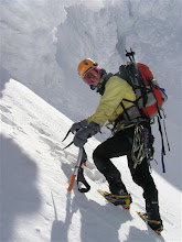
Mostly, hiking in YangMingShan park, there are cement or rock trails and steps. Tons of steps. Un-even steps. And more steps. And more cement. It's rather rough on the feet, and the knees. And it's all covered with a nice thin layer of moss which turns especially slippery when wet. It was nice when a friend of a friend got a friend of his to take a bunch of us for a hike on one of the "challenging" hikes in YangMingShan park. There was a lot of stone and cement, but there was also a section where there was an extremely steep dirt and rock trail. There were ropes strung from tree to tree so that we could hang on as we went up or down the steep incline. We wore gloves. Here's a picture of us just before we descended. We all had shiny new gloves (the common painting and everything else work glove, here), which were soon not so shiny and new. . .

And here's a picture of a descent:

And then, last weekend, I did another Richard Saunder's hike - which was kind of sort of in the country-side to a nice waterfall, and then a couple more small hikes on Saturday, and then, a real treat, a REAL hike on Sunday. Sunday's hike had been planned weeks in advance, by my apartment's owner's agent, now friend (also now "gan meimei" - sort of adopted little sister), Amy. Amy said that we were going for a nice hike south of Taipei - a place called ManYueYuan near SanXia - and she would cook us a nice picnic lunch. Our little group consisted of Amy and two of her friends, whom I'd previously met, and one of my hiking employees at work, Simpson. People were asking me what I was going to do for weeks in advance, and I told them I had no idea, no idea how we were going to travel (I had assumed by train, since we were to meet at the Taipei City Main Train station), and no real understanding of where or what sort of hike it was. But it didn't matter, since none of the hikes were too difficult, and I didn't care, particularly, where I was going. It was a new place! Great! Let's go! Amy did say something about not having gone with this "climbing" group, before, but her English, while very good, leaves room for some differences in terms for describing things. When we all met at the train station, we were directed to a bus. On the bus, people with trekking poles, backpacks, and gaiters covering their lower legs got on. Amy commented on how "professional" they looked. The hike leader greeted me in English, and gave me the brochure, in Chinese, of all of their future hikes. And then gave me one with our current hike. The only thing that I could read was that we were going to be going 17km (10.5 miles). It made me a little concerned for my little sisters (Amy & her 2 friends), since 2 of them were dragging on our short little walk around the "town" of DanShui a month or so, earlier. However, I assumed that they all knew what they were doing, and I had been the only clueless one.
Later, I discovered that they thought that they were headed to a nice little park, where we would pretty much look around and take in the views, and have our little picnic. Instead, we all climbed 2 peaks, with a lot of ascending and descending. And with these hiking clubs, the good thing is, you get dumped off at one end of the trail, and picked up at the other end. The bad thing is, if you make a mistake, and think that you're going on a short hike for a nice picnic and views, you still have to do the whole hike. There is no turning back, just pushing forward . . My little sisters bravely trudged on, and completed the entire hike, not that they had a whole lot of choice. . . I remember Amy's elation when she made the top of the peak. I don't think that she understood that she was at the top of the FIRST peak at that time. Here is a picture of Patty and Amy, thinking that they had arrived! They had conquered! Before they understood that they still had another, higher, peak to climb and at least 1/2 of the hike yet to go. . .

This picture is looking North, by the way. Taipei is in the northern part of the island. Isn't it impressive how many mountains there are? We were not that far south of Taipei.
This hike crossed streams, was all dirt, except for the very beginning and end of the hike. The end of the hike was in a resort area, and so steps were provided - fortunately, most were wood. It was a very nice hike, even if my little sisters weren't expecting it. . . Little sister Debbie wrote up her tale of woe, and put more pictures on the web at:
http://spaces.msn.com/members/franbie/ (look at her September 25th entry, which she kindly translated into English for me, and at the photo album in the upper right hand corner, select the button that allows you to see the "full size" pictures, and then select the album that has a 9 and 25 and "car" in the name. She and Patty tried to capture how steep the trail was in places.)
I just noticed that on one website (http://www2.blogger.com/www.typhoon2000.com) our Typhoon has been classified as a category 4 (wind gusts of 131 to 155 miles per hour) expecting to hit Central Taiwan. However, even here, about 100 miles away, the wind is really howling now, and the rain is coming down quite steadily.
Dang - no hiking, tomorrow. . .
leora