There
are tons of stories to tell, as one might expect, from an adventure that
started from an idea on November 5, 2013 to getting on the glacier on May 1,
2014, to getting to the summit on May 23, 2014, to getting off of the glacier
on June 1, 2014, and, finally, to returning to home, to Portland, on June 7,
2014. So, for 6 months, my focus was on planning the climb, including all
of the logistics associated with the climb, all of the training necessary, and
all of the gear and food needed to accomplish the climb. And then, of
course, we spent another month actually *doing* the climb.
In this write-up, I’ll zero in on the summit day.
All
of that planning and training and preparation resulted in successfully getting
to the summit of Denali, referred to as Mt. McKinley on the USGS maps, on May
23, 2014:


We
started our summit day around 11am. It took us about 12 hours to get to
the summit from our high camp at 17,200ft. The weather forecast had not
been promising, but it sounded as though it would be the last chance for a
couple of weeks, so we decided to go for it. It took about 2.5 hours to
get to Denali Pass, around 18,200ft.
Here’s
a shot just as we were starting up the steep part toward Denali Pass:

You
can see a rope team in front of us. We have no idea if they made it or
not, as we lost track of them. I turned around and took a shot looking
back at Mt. Foraker and where we’d come from (you can just see a rope team of 3
heading out of camp) – our camp is just out of the picture on the right:

That
team of 3 did turn around. At this point, the weather was still pretty
clear. However, it started to change as we got closer to Denali
Pass. You can see the weather that we were headed into, in my last shot
that actually has Denali Pass in it:

and
by the time that we got to the pass, the wind was blowing, furiously, and the
clouds had moved in. Notice that in the above picture, Jay still had his
glacier glasses on – he had to change them to goggles at Denali Pass (I assume
that I did, as well). We were soon enveloped by a whiteout, unable to see very
far at all. This was not how I’d envisioned our summit day *at all.*
We decided to press on. After a while, we saw a wand (a garden stake, sometimes with a little flag on it), and then decided
that as long as we were seeing things like wands, and felt that we would be
able to return to our high camp, safely, we’d press on. At one point, we
got a little turned around as to which way we should be going, but we solved
the issue by agreeing to go up. We knew that there was a dip (where we
would lose some elevation) in the route at some point, but that dip would
happen many hours away from where we were, so up was the way to go.
We
started seeing folks coming down who’d been successful. One of them told
us that we had about 6 hours to go. We’d already spent about 6 hours
climbing, so we hoped that he would not turn out to be correct, but, alas, he
was very correct. On our return, I wondered how in the heck he’d been
able to estimate that, since, on our descent, it only took about an hour to get
to that point!
After
several hours, magically, we were able to start seeing farther, and after some
more time passed, the clouds lifted, entirely! However, it never got
warmer. On my feet I wore two thick pair of wool socks, my Scarpa double
plastic boots, overboots, and crampons. On my legs I wore Columbia
expedition long johns with Mountain Hardware hiking pants over that, heavy
fleece pants over those, and finally, down pants over those. On my top, I
wore a thermal t-shirt, the Columbia expedition long john top, a nylon running
top with a hood, an expedition fleece long john top, a synthetic “down” jacket
(with hood), a “soft shell” jacket (with hood), and the huge parka with a
hood. I think that I was also wearing my ball cap for shade from the sun,
and I’m pretty sure that I was wearing my helmet. On my hands, I had on
liner gloves and my Alti-mitts that have a mitten liner, and a lot of down in
an outer mitten. I don’t remember being cold that day, but I also know
that I was never tempted to take anything off. All of our water froze,
even though we carried it in bottle parkas, and each of us had a liter in our
packs as well as a liter on the outside of our packs (in a bottle parka).
Here
is our only picture of the final ridge from below the ridge (and from behind
yet another hill). Pig Hill, the rightmost face of that distant ridge,
represents most of the last 600 ft of the climb. The white ghosty-looking
stuff is snow blowing off that hill:

Once
at the top of Pig Hill, we “just” had to go along the top of the ridge:

Since
we didn’t know where, exactly, the summit was, we just had to keep going until
we got there (fortunately, it was obvious when we were there!).
I
don’t remember how many breaths per step I was taking at various times, but I
know that when we were going up Pig Hill, I was up to 4 breaths per step.
So it was taking about 7 seconds for every step that we made. If you were
to try that, now, in your living room, I’m sure that it would feel as slow as
molasses, and you’d wonder how anyone could accomplish anything at that slow
pace. The fast guys that everyone reads about in the papers can do it a
heck of a lot faster (so could Jay, for that matter, but he was being nice and
sticking with me, and helping me to go at a pace that I could sustain).
I’d
not had much sleep the prior night, because the wind was howling most or all of
the night, so I was tired to begin with on that summit day climb. When we
got to that last bit, going up Pig Hill, I was nearly falling asleep while
walking. I told Jay that I really needed a little rest, and I sat down
and lay my head down on his lap. Someone coming down asked him if he had
been able to notify the National Park Service. He told the guy that he
hadn’t tried, and was wondering why he should do so. The person gestured
toward me. No, no problem – she just needed a little rest, he told the
guy. And, at that point, I was able to continue on, and didn’t need to
rest, anymore. I guess that the guy thought that I was in some deep dark
trouble. . .
Here’s
a shot toward the North Peak from the summit:

While
planning the trip, I had definitely wanted to scale the North Peak as well, but
we were pretty worn out after the South Peak, and we knew that the weather was
going to get bad for a while, and we’d already used up most of our weather
days, so we decided to just take a pass on it.

We
couldn’t seem to get the lighting right on the above picture – mostly, I was
trying to show off my wind burned cheek – I looked like a burn victim (I guess
that I was!) after the skin peeled from my cheeks and side of my face. I
still have a trace of that burn scar on my left cheek, but it’s nowhere near as
noticeable as before. Also present in the above picture are my puffy
eyes. Jay didn’t seem to suffer from that particular affliction, but I
sure did – almost every morning my eyes were all puffy. It’s due to
the altitude, although I confess to not actually understanding exactly why it
happens. . .
On
the summit, one of the first things I did was take out Wim’s SPOT device, turn
it on, and push on the “custom message” that would send out the “We made the
summit” message to an email list, and post it to facebook. I had no way
of knowing if any of these messages were actually making it through, and this
one was no exception, but I’d gotten used to how the device behaved, and
assumed that when it stopped blinking the little message light, that the
message had been sent. Unfortunately, even though it appeared to be sent,
it was never received, so I found out when we returned from the mountain, that
people hadn’t realized that we’d made the summit! And here I thought that
everyone would be cheering from the sidelines. Poo! (as Jay would say!)
We
arrived at the summit at around 11pm. Look at where the sun is above the
horizon on this first picture that I took from the summit, looking back at
Denali Pass:

I should point out that at the bottom left of the picture, there are a couple of wands lying on the ground, and at the very bottom of the picture, are the tips of my feet, with my crampon points sticking out.
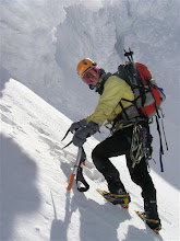
We had a lot to do on the summit –
summit kiss and hug, pictures of each other (at the beginning of this piece!), blowing kisses to our
friend, Linda, taking a picture with the CureJM (Cure Juvenile Myositis)
banner:

And
saying a final good-bye to my friend, Monty:

I
noticed that I’d lost my iphone while I was on the summit, but I looked all
around and couldn’t find it, anywhere – I even took off my jackets, thinking
that it must have slid into my pants or gotten lost on an inside layer of a
jacket. No such luck. I couldn’t find it, anywhere, so lost all of
the photos that I’d taken on that device, as opposed to the photos I’d taken on
my camera.
Jay
was worried about us having to get down in the dark. HAH! I wasn’t
so worried, as I’d not noticed real darkness in at least a week or so.
However, old habits die hard, and when midnight approaches, some of us innately
expect darkness to arrive soon. So, after spending a pretty full 40
minutes on the summit, with no one else in sight, we turned around and headed
back. There were some parts of the ridge that were very narrow, where a
fall would likely have been fatal, so Jay slowed us down so that we’d stay
focused on making sure that we weren’t reckless in our descent on the parts
where there was a lot of exposure. Much of the descent was fairly benign,
so we were able to go pretty quickly on quite a bit of it. And, by the
time we got close to Denali Pass, it looked as though the sun was really
setting.
I’d
not been particularly careful on the wide places where falls were not a
problem, and so fell a couple of times. It turned out that Jay saw this,
and concluded that we were getting tired, so he was extra careful going from
Denali Pass toward our camp, which was good, since this is where many people do
fall on their return, and not a small number of those falls have been
fatal. We spent probably about an hour and a half on this section of the
climb, and when we got to the base, with just the long stretch to our camp to
go, we were able to see the horizon, again. Dang if the sun didn’t look
as though it were in the same position we’d seen it in just a few hours ago,
only this time, we realized that it was now rising, when before, it had been
setting – all in the northern sky. . .
By
the time we got back to camp, it was either 3:30 or 4:30am on the 24th
– so we’d been climbing some 16 or 17 hours. We decided to just sleep
that day (as opposed to packing up and heading down). While some part of
us was very happy about the accomplishment, another part was very tired, and
yet another part knew that we still had a lot more to go before we could say
that we were “done” and truly successful on the climb.
May
all your summits be bright!
leora