Thursday, December 31, 2015

Honeymoon #3 (Australia) - The Map & Driving


On August 12, 2015, we hopped on a plane for Australia (honeymoon #3) and, on October 24, went over to New Zealand (honeymoon #4), and didn’t return until November 19, 2015.  It was a long trip (over 15,000 photos!), so I’ll attempt to give a bunch of little short stories over the next months (before we head off for more adventures!) about the travels.

Here is the map overview (click any picture to enlarge that picture):

With details visible here (for the interested: you can see all of the places we went, and our route – you can zoom in, and you can switch to a satellite mode).

What is pictured above turned into 13186 miles (21220 kilometers) of travel!

Fortunately, before we got into a rental car, we had a “soft landing”.  Friends, Peter and Elizabeth, who happened to live near Sydney, picked us up and took us to their house, which backs onto some park land.  This allowed us to recover from our flight, get used to having to drive on the left hand side of the road, without having to actually *do* the driving, get a wonderful introduction to the local birds (gorgeous cockatoos, galahs, parrots of all sorts) and plants, and hear about the local animals, most of which exist (in the wild) only in Australia.  This gave us a wonderful base of knowledge for the rest of our trip around Australia.

The above sign was mostly seen on the roads to and from Uluru (Ayers Rock).  Another park had painted arrows showing the direction of travel in a lane in front of pull-offs, or upon exiting a dirt road.

We actually had one timeline on our trip, and that was having to be in Darwin (where we also have friends) on August 26, to pick up Ed (travel buddy and friend from high school era) and Rebecca (wife of a high school friend who has joined us on a couple of occasions) who were flying in.  We were advised by many to fly to Darwin (extreme middle north of the country) from Sydney (south east of the country), because it’s so far, but Jay and I had been driving all over the US, and loved it, so, why not do that in Australia, as well?  When we rented a car, and told the rental agent our plans, he physically backed away from us, started to ask us “Do you know how far that is?” stopped mid-question, looked beseechingly at Peter, who’d accompanied us to get the car, and asked him if he’d explained to us just how far it is?  Peter nodded his head, and told him that we understood the task we were taking on.  And, away we went. . .  we started from Sydney late afternoon on August 17th, and made it to Darwin, going some 3000 miles ( 4828km), by the 24th.

That segment of the trip taught us many things about driving in Australia.  We noticed that Australia’s roads are, in general, narrower than those in the US, and, except for areas very close to the major cities (of which there are only a few), there are no major highways, like the interstate highway system in the US. We soon learned that the major roads, on which we would be spending the majority of our time, were these 2 lane roads, sometimes wide-ish and most of the time, narrow. We also learned that finding a place to stay by about 4 pm was the wisest move, for many reasons, but mainly because we didn’t want to be caught driving at dusk, when most of Australia’s wildlife wake up and start moving around, most notably, the kangaroos.  The first couple of days, we had some very close calls with kangaroos, and after that, we stuck to full daylight for driving:

Besides having to get used to which side to drive on, we also had to get used to where in the lane the car is, because, if you’re used to driving on the right side of the road, the car extends a little bit beyond you on the left, and a LOT on the right.  Well, if you drive on the left side of the road, the bulk of the car is to the LEFT of you, so positioning the car is a little different.  I believe that folks used to driving on the right tend to lose a lot of the left-hand car mirrors when driving on the left side of the road.  Fortunately, we never lost any pieces of the car, but the left tires did spend some time off of the left side of the narrow road. . .

Another detail is that the signal lever is on the right hand side of the steering wheel (unlike in the US), while the windshield wipers are on the left.  The windshield wipers were constantly going, whenever a turn was anticipated. . .  What I found even more amusing is that *after* we returned, Jay, having never really gotten used to the signals being activated by the right hand, was constantly reaching for the signal lever with the right hand after we returned!!! 

Neither of us had any difficulty returning to the right hand side of the road, upon returning to the USA, which actually surprised me for myself, as I’d gotten quite accustomed to being on the other side of the road, and being on the right hand side of the road would scare me, in Australia or New Zealand, and so I was afraid that I’d yell at Jay to get on the other side of the road, mistakenly, after returning.  Hasn’t happened, though (thankfully)!

I noticed that there are some things that I’ve internalized from living in the US for so long.  One thing that I’ve internalized is that yellow separates lanes going in different directions.  Well, in Australia, those clues do not exist.  White dash lines exist between lanes going in the same direction, as well as going in different directions, but it took a while for me to understand why the roads seemed so confusing to me.  Australia does use yellow, but usually to mean that there are parking restrictions, and that yellow is near the curb.  (Yellow on the curb is frequently used for a similar purpose, usually “no parking” in the US, but not quite in the same location on the road as it is in Australia.)  There was one National Park that had no lines on most of the roads, and then, instead of marking the middle of the road, it put in yellow lines on the side of the roads (don’t park!).  With the narrow roads, oncoming cars would frequently join us in our lane, which was quite nerve-wracking, so I thought that if at least the midpoint were marked, then they would KNOW that they were joining us. . .

In the Northern Territory (where Uluru/Ayers Rock and Darwin are located), there were stretches of road where there was no speed limit.  So, naturally, Jay had to see how fast he could go.  The car’s limit was 200km/hour, which is a little over 124miles/hour:

However, as the speedometer went up, the fuel indicator went down. . . rapidly.  We started to worry if we’d make it to the next gas station, usually quite distant, in those parts, like maybe 150kms(93miles) distant.  Fortunately, we didn’t out drive our capacity, ever.  But speaking of gas stations, we experienced anywhere from about $1.29/liter on the really cheap side, to more commonly $1.60/liter, to sometimes $2.00/liter, which is about $5, $6.5, and $8 per gallon in Australian money.  This translates to anywhere between $3 to $4.8 to $6/gallon in US dollars.

One other joy we had were the Road Trains.  They are kind of like semi trucks.  Here, in Oregon, we sometimes have triple trailer trucks, and they are definitely long – there is no doubt, but Australia wins the length award, with trucks sometimes hauling 4 railroad-sized train “cars” behind them (in this picture, there are only 2):
Note that the van in front is driving off to the side, and that the Road Train takes up most of the width of the lane.  Here is a sign warning about the Road Trains: 

53.5meters is 175ft!   For comparison, in Oregon, the maximum length for a semi with 2 trailers, without a special permit, is 60ft.  Passing a Road Train was exciting, in a nervous sort of way. . .

I got a kick out of this, when I saw it – a truck towing a 3-car Road Train:

At least, that’s what appeared to be happening, to us. . .

Regardless of any difficulties in driving, we still preferred it to flying internally, within the country.  The car became our traveling “home” even though we always either camped or found a place to stay, frequently in a hostel or backpacker place.  And, although we rented a darkish grey car in Perth, we wound up with a reddish tinged car:

before we took it to the car wash before returning it.  The red came from all of the red dirt roads:

May you always know which side of the road to drive on. . . (And which way to look when crossing the road!)

leora

Wednesday, July 29, 2015

Honeymoon #2


The purpose, and inspiration for our second big trip in 2015 was to hit a number of state high points (given that we’re now on a mission to reach the highest point in each of the 50 states of the United States of America).  I was hoping that we would knock off another 11 state high points, including all of the more difficult state high points, and the highest of the state high points in the west and southwest.  However, we met with weather issues for our very first expected high point, Utah’s Kings Peak.  And we had more weather issues, and wound up rearranging our trip several times to get in *any* high points, let alone the high ones.  We finally started to get some traction after taking a little “vacation” in Rocky Mountain National Park on the advice of a friend.  We then had a weather window to climb Colorado’s highest, Mt. Elbert.  After more storms, and more visiting, we decided to get some easier ones in Oklahoma and Kansas, and then Texas – went back to New Mexico, and then, suddenly, had extra time.  I plugged a whole bunch of high points around the states into my planning program, and discovered that if we *just* hit the high points, and didn’t visit anyone, we could knock out quite a few – and we did – we wound up visiting a total of 20 state high points this trip, bringing our total high points visits up to 39, with only 9 northeastern states, Hawaii, and Mt. Rainier to do!!!  (While we’ve both done Mt. Rainier a number of times, we have to do it, again, together, for this 50-state project. . .)

Here’s our state high point collage:


For some reason, this seems to be the year of the turtle.  We were seeing them all over!  On this trip, we sighted our first, a box turtle, in Missouri, and then, in Michigan, we saw a snapper laying eggs, and then a couple of painted turtles, a couple red eared sliders, and another snapper.   All the eggs had been raided by some predator or another.  Here is a collage of most of the animals that we saw on the trip:


In order of the photos in the collage –
Row 1, Picture 1: we managed to see the lizard that a sign told us to look for while we were checking out the Valley of Fire State Park in New Mexico [not to be confused with what appears to be a more famous Valley of Fire in Nevada].  Alas, I can’t remember the type of lizard. . .
Row 1, Picture 2: we saw this tiny little fellow in Guadalupe Mountains National Park.
Row 1, Picture 3: bighorn sheep in the Taos Ski area of New Mexico.
Row 1, Picture 4: a bear in the Blue Ridge mountains of North Carolina.
Row 1, Picture 5: longhorn cow and her calf in Mount Rogers National Recreational Area
Row 2, Picture 1: another longhorn cow and her calf in Mount Rogers National Recreational Area
Row 2, Picture 2: one of the many wild ponies that we saw in Grayson Highlands State Park, which is part of the Mount Rogers National Recreational Area.  It seems that most of the visitors we saw were trying to get a glimpse of the wild ponies.
Row 2, Picture 3: box turtle in Taum Sauk Mountain State Park in Missouri
Row 2, Picture 4: Canada geese with their brood, commanding the secondary highway in southern Wisconsin.
Row 2, Picture 5: snapping turtle in Stony Creek State Park, Michigan
Row 3, Pictures 1 and 2: painted turtle in Stony Creek State Park, Michigan
Row 3, Picture 3: crawdad in Stony Creek State Park, Michigan
Row 3, Pictures 4 and 5: 2 different red eared slider turtles in Stony Creek State Park, Michigan
Row 4, Picture 1: Moose running through our campsite at the trailhead for Gannett Peak, Wyoming
Row 4, Picture 2: Some of the horses that we saw packing in (with mules) both people and supplies to Big Meadow in Bridger National Forest near Gannett Peak, Wyoming
Row 4, Picture 3: some bucks hanging out on Froze-to-Death Plateau on the way to Granite Peak, Montana
Row 4, Picture 4: goat at our campsite near Tempest Mountain on the way to Granite Peak, Montana
Row 4, Picture 5: pika near Mystic Lake, Montana

Not pictured were all of the wild turkeys that we saw in the Blue Ridge mountains, the cave swallows swirling around the entrance to Carlsbad Cavern before dusk, and the many bats swirling out of it, as soon as dusk actually arrived.

With a two month trip, and so many fabulous sights, I could probably give about 10 slide shows.  For this, though, I’ve chosen about 20 different things that I thought were interesting to share.

Here’s a sample of us getting ready for a climb:

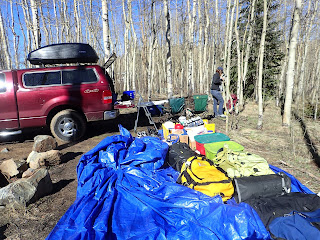
In this particular case, we were at the trailhead for the Mt. Elbert climb in Colorado.  We had this HUGE tarp that we were able to put everything onto, and still have room to have an area for sorting gear, another area for packing up what we were taking, and enough tarp to cover everything during the night while we slept in the back of the truck.

We were pleasantly surprised that we could get as high as we did on Mt. Elbert (I think that we got to around 10000ft in the truck, and were amazed that there wasn’t much snow around) before we had to go on foot.  By about 12000ft, we had to don snowshoes, though, so you’ll see that I have them on in the picture.  At the tops of all of these mountains (especially for these state high points), I’ve been flying the Cure JM (Juvenile Myositis) banner:

I liked this picture because it clearly shows the snowshoes, and has such a wonderful, wonderful view of the surrounding mountains.  The Cure JM Foundation wrote up a nice article about this endeavor (see the 2nd article at this link).

Somehow, I’m always struck by the oil pumps – these were in eastern Colorado:

There were sooooo many.  Ultimately, they feed the truck. . .

After taking in Mt. Sunflower in Kansas, we headed down to the SW corner of the state, where there are some National Grasslands.  When I was trying to touch every state a couple of years ago, I stayed in these same Grasslands, only in a different spot.  Our camp in this one was simply excellent, and not another soul around:


We planned on seeing Carlsbad Caverns National Park (New Mexico) as part of the trip, since I’d heard so much about them (all bad) and we were going to be so near them when going to Guadalupe Mountains National Park.  I continued to receive more “it’s not worth it” opinions from anyone I told.  Well, the ruse worked!  We were pleasantly surprised – we got there in time to see the “bat show” – the thousands of bats exiting the Caverns at dusk, swirling out, and the next day, we went back and walked all around the parts we could go without being in a tour group.  The caverns were amazing – in form, and in size:

With the above picture, I tried to give some idea of just how huge this thing was – the one cavern (and they’re all connected to one another) was over a ½ mile long.  Really, really impressive.  And the curtains, stalactites, and stalagmites were all really, really impressive.  So, go there, but expect it to be a waste of your time, and then you’ll be pleasantly surprised, as were we!

We also stopped at Three Rivers Petroglyph National Site (New Mexico), where there are thousands of Petroglyphs (or as some people call it, old time graffiti).  Below is just a sampling – the place was  absolutely littered with them:


In Texas, from the top of Guadalupe Peak, we looked down on this – it looks like a carving, to me:


I was impressed with some of the artwork, I have to admit – this saguaro cactus imitation just struck my fancy:

Barbed wire!!!  And it looked sooooooo good!

Jay was trying to capture sunsets, especially from my travel buddy, Ed’s back deck.  He snapped this one and no, it is NOT photo-shopped!!!!

The mountain providing the backdrop is the Sandia Mountain, east of Albuquerque, New Mexico.

Can you see me in the middle of this photo, climbing up Wheeler, in New Mexico?


Oh, and while in the Taos area, we had to check out the “earthships” - off-the-grid houses built into the ground using various materials (for example, old tires):


In nearby (ha, ha) Louisiana, we saw many of these very, very long sheds/barns.  We never did figure out what they housed –I’m hoping that one of you will know. Maybe mushrooms?


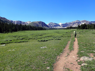
Going in to climb Kings Peak (13,528ft) in Utah had us going through a huge basin with mountains all around.  The basin, itself, was at 9,000 to 10,000 feet:

And, yes, that’s me, hiking along. . .

This next one is from our campsite, looking toward the mountain that we would be hiking up the next day.  Kings Peak is in the middle, with snow on it, although the top is not quite visible.  And, while we did descend by going through the chute between the other two peaks, we went up by going around the peak on the left.

And, by going around that peak, we saw another basin, with more mountains all around it:


After having climbed both Kings and Gannett Peaks, we drove on to meet up in Montana with our climbing friends for Granite Peak.  On the way, we took a really fast tour through Grand Teton National Park and saw the Grand Teton:
It was a rainy/cloudy day, so we were lucky to have seen it!

We then took a fast tour through Yellowstone (we got to see Old Faithful!), and saw little fountains like this one:


Both Gannett and Granite deserve their own little slide shows – both very spectacular, however, I thought I’d leave you with a couple of shots from the Michigan wedding reception.  I wore the same flowery t-shirt that you can see in some of the easy high point pictures and jeans, disappointing many, I’m sure.  However, I had a plan. . .  my friend, Rebecca, while we were visiting her place on the west side of Michigan, had shown me this nice Bavarian dress that she’d purchased years ago in Germany.  It happens that the restaurant where the reception was taking place was a Bavarian restaurant, so, in the middle of the reception, I slipped out, and put it on, and now, none of you can ever truthfully say that you’ve never seen me in a dress:

(Rebecca is the one who is half-shown, laughing, in the background.) 

And for the final picture, since, this was, after all, a honeymoon – is of the two of us, from that Michigan reception:


I do feel as though I’m inside a fairytale. . .

leora

Monday, July 27, 2015

Honeymoon #1


At the beginning of the year, we planned 3 major trips (Mexico, Southwest state highest points & Michigan, and Australia and New Zealand), all before we even knew that we were going to get married, let alone that we would happen to get married in April.  Our first trip was planned for Mexico in late April, with our friend, Shu-ling, and her boyfriend.   She took to calling the trip our honeymoon trip, so we started calling all of the trips we’d planned “honeymoon” trips, since they are, after all, after the wedding took place.  This is a brief look at honeymoon #1, in Puerto Vallarta, Mexico.

Shu-ling was an old hand at vacationing in Puerto Vallarta, and had been there many, many times, before.  She’d rented a wonderful apartment overlooking what everyone called “the boardwalk” although it was made entirely of cement.  Jay spent a LOT of time sitting on the balcony watching all of the entertainment, below.  In this picture, he captured 2 female singers/musicians who were about to set up, a man selling all sorts of handbags, a cotton-candy/apple vendor, and a donut vendor:


We all spent a lot of time on the balcony eating wonderful meals that Shu-ling whomped up:

We all enjoyed watching sunsets from the balcony, as well:


We did go out and investigate the city, beaches, and other areas.  Here is a picture of Jay and me, courtesy of Shu-ling, at a river on one of our hikes:

I had a passerby take a picture of all 4 of us on this wonderful city staircase, but, alas, it didn’t come out well, and that was our only 4-some picture, so we’ll have to do with just the 3 – Shu-ling, Jay, and Bret.  Note the tile on the edge of the stairs – in some places there was different tile on every stair edge:

And finally, after a week, we moved to a time-share unit that was more northerly, near the marina (for those familiar with Puerto Vallarta), and when Jay and I got up to run on the beach, we had to get the gate to the beach unlocked.  When the guy unlocked it, he knew to look for baby turtles that had hatched and followed the lights toward the resort area, instead of following the moon’s light to the sea water.  Below is a picture of me with 3 of the baby turtles as I took them from the sand wash “sink” where they were caught, to the sea water:

It turns out that every year, the beach resort people try to capture all of the eggs and put them in a storage unit, and then release the turtles when they hatch.  They’ve seen a marked increase in the survival rate by doing so – the turtles had apparently been teetering on the brink of extinction before this practice was started. 

And, while we are on the topic of animals, we saw many iguanas while over there.  Here was a particularly nice specimen:


Thank you, Shu-ling and Bret, for sharing your accommodations with us, and for giving us such a great wedding present and honeymoon!

May you all have such generous friends in your life!

Leora