Monday, December 16, 2013

Some Local Ice Climbing


The northwest part of Oregon, where I am, is sort of known for its year round mild weather.  Pipes are not protected from the elements, because it so rarely gets below freezing, here.  So, to do ice climbing, here, I usually have to go into the mountains and climb in the crevasses of some glaciers.  However, the last couple of weeks, we had a tremendous cold spell, so some friends (Wim, with whom I went to Aconcagua, and Steve – new to all of you) and I were able to go into the “at sea level” Columbia River Gorge, just east of Portland, and climb a (mostly) frozen waterfall!

Here’s our objective:
The waterfall that we chose to climb is just east of Crown Point, where the million dollar bathroom, Vista House, is located, and it has the glorious name “The Crown Jewel!”  Who wouldn’t want to have the Crown Jewel under their belt (I say with all puns intended)?

For some reason, only Steve thought to take a picture of the entire waterfall from the base of the climb, before we started, while it was still light (picture courtesy of Steve):
Wim was our stud lead climber – i.e., the one who didn’t have the daylights scared out of him at the thought of the rope coming at him from the bottom, where, if he fell, he would actually fall.  Steve and I were happy to have Wim climb up, put in protection (for himself) on the way up, so that if he fell, maybe he’d only fall twice the distance from his last piece of protection.  And then Steve and I would each climb up, with the rope heading UP from us, to Wim’s belay device, where, if we happened to fall, we’d go at most a couple feet or so.  Even though it had only been a week since I’d climbed some ice with Wim on Reid Headwall on Mt. Hood, it felt as though it had been ages (and it had) since I’d done such a continuous climb of waterfall ice, which tends to be a tad more vertical than what I normally experience on the mountain.  And, I knew that I’d fallen from an ice pillar on that same day, so I think that I was still a little traumatized from that.   Here’s a picture of me on the pillar (in the Bergschrund on the south side of Mt. Hood) just before I peeled off on the day after Thanksgiving (11/29/13 – picture courtesy of Wim):
Ice climbers will know that the reason that I peeled off is because of my poor form on the pillar.  I excel at poor form when the ice is actually vertical. With practice, I’m sure that it will get better. . .

So, back to the Crown Jewel.  When doing something like this, I tend to like to check and even double-check everything to make sure that everything is connected the way that it should be so that people are as safe as they can be, given the circumstances.  So, before Wim headed up on the climb, I asked 
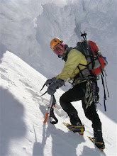
to check his gear – here I am doing that(Picture courtesy of Steve):
I’m set up to belay him (catch his fall, if he should fall) as soon as he starts putting in protection, and I’m clipped to an anchor (carabiner clipped into a small diameter rope that is tied around a huge tree), behind me, because if Wim *were* to fall, being heavier than I am, I’d likely go flying if it weren’t for being attached to that anchor.

Now that we’d checked each other out and made sure that everything was correct, I was happy for Wim to climb.  He felt very comfortable on the ice, and frequently climbed farther above his protection than I preferred, so I would keep calling up to him how far above his last “piece” he was.  He’d wait until he was in a good, stable position, and then put in some protection.  When he got to the top of the first pitch (about as long as the rope was), he built a nice anchor:

This shows the top of the ice screws with the holes that the carabiner clips onto, and then from each of the three screws, he’d attached another small rope, tied it off in the direction of the expected pull.  When I took this picture, Steve’s carabiner lower right corner was clipped into the anchor, and Steve was also clipped into the rightmost ice screw with another bit of rope coming off of him.  He started belaying Wim up the second pitch, while I dealt with some rope for another team of climbers who showed up that day.

Here is Steve:
belaying Wim:
Wim stopped a moment in his climb to take this picture of Steve and me standing at the top of the first pitch (photo courtesy of Wim):
That’s me with the orange helmet and hand raised in the air.  The guy in blue is one of the other climbers we’d helped.  Steve’s in the red attire.  Steve’s and my backpacks are small dots on the ground far below us.

After Wim got up, we had a plan for Steve to climb up, first, so that he would have plenty of resting opportunities, but Wim wasn’t able to get the slack out of his rope.  After several tries, admonishments via radio, and some frozen hands (Steve’s) that we spent some time warming up, I finally realized that Steve’s rope must be stuck, somehow, and that I should just climb, and clean (take out) the ice screws on the way up, and that likely I’d be able to free Steve’s rope, and then he could climb.  Steve took this picture of me from below, while he was waiting (photo courtesy of Steve):

My left foot is *solidly* placed (trust me!) with the 2 front points of the crampons that I’m wearing, and my right foot is actually quite comfortable sitting on top of what we refer to as a mushroom.  For some reason, my hips aren’t smashed up against the ice, as they should be, but that’s part of the poor form that I need to work on. . .  My form wasn’t *always* this poor, but it is in this picture.  Wim’s head is a little dark ball seemingly at the top of the two ropes.  (And, Hoa – those are your crampons – for some reason, I mistakenly picked those up instead of my own, but they worked fantastically!)

A little while later, Wim took this picture of me from above (photo courtesy of Wim):
You can’t even see Steve, but he’s down there!  What struck me, looking at this, was that when I was climbing the waterfall, I was thinking that it was vertical ice.  When Wim and I were discussing it later, he made some comment about “well, the ice was never really vertical”!  It wasn’t?  Well, no, it wasn’t – there really was a slight angle the whole time, as evidenced by all of the other pictures, above, but being on the ice, it had *felt* vertical to me, which is why I need to practice, more.  I knew that I didn’t have a hard time climbing it, which should have been my clue, since it’s as soon as it becomes really vertical that I have real difficulties climbing ice.

This climb took us hours – partly because we wanted to take pictures, partly because we helped out the other team, partly because Steve’s hands froze and we had to warm them up, partly because it took us so long to figure out that Steve’s rope was just plain stuck, and partly because climbing and putting in protection just takes a long time.   As we climbed, it got warmer.  As it got warmer, we could feel the difference in the ice, and started to see more and more water flowing UNDER the ice (this was, after all, a waterfall).  We started to fear for our safety if we were to rappel down this waterfall when we were done.  What if the anchor in the ice that we were using to rappel off of were to pull the whole chuck of ice off?  Or maybe we would crash through some of the icy waterfall and get seriously wet.  We were already quite wet because the waterfall was spraying water, but not seriously wet.  We were pretty close to the cars by some standards (just a mile or so away).  We decided that the safest alternative was to simply “walk off” the top of the waterfall.  This was an adventure in itself, since none of us had ever done this, and while we knew where we needed to get to, we didn’t really know how to get there, so we just guessed.  I saw what looked like a pretty clear path, and started up that.  Wim and Steve followed up the very steep, very moss-covered rock:
I tried to give a sense of how steep this was.  Those are railroad tracks, down below, with a snow covered, iced-over pond, next to it.  We kept our crampons on, because they made it easier to get purchase in this moss-covered dirt that we were climbing. 

We had views from places that most people will never be:
 
That’s the Columbia river on the upper left, with the state of Washington upper left.  On this side of the Columbia, we have I-84, from which we heard truckers tooting their horns at us all day (maybe they were impressed?), and then this inner little river that formed a pond, below us, and then the railroad (very hard to see in this picture, but it’s there), and finally, cliff side of the gully that we were climbing. 

We eventually made it through all of the brush, and growth to a ridge that led to the road, at which was posted a “no trespassing” sign (oops!), and then we walked up the road to and around the Vista house.  Wim told us that he’d read that there was a gully on the west side of the Vista House that made a decent return, so we headed over there.  Again donning our crampons, in spite of the dirt and rocks that we knew would dull them, because we figured it would give us the best purchase, and, in case we did run into frozen ground or ice, it would be easy if we had the crampons on.  We did run into both frozen ground and ice, and the crampons did, indeed, make the going easy.  Wim took a shot of me as I dashed down the gully (photo courtesy of Wim):
I was doing something that we call “downclimbing” – face toward the ground, and going down on all fours.  It’s incredibly fast and safe on steep terrain, which this was.  Fortunately, this gully, while steep in many places, was definitely pretty easy to go down, and never ended in a cliff, which we would have had to rappel down.  We were able to get all the way down to the railroad, follow it to the base of the ice climb, pick up our packs, and then head back, getting to the car about a ½ hour or so, later.  It was after sunset, but with all of the snow, and a bit of moon showing, it was plenty light enough for us to get to the car.  We did worry that the gate might have been closed because we parked the car in the state park parking lot, and it said that it was open from dawn until dusk, but the gate was still open, and we, with our muddy faces, and wet clothes, piled into the car and headed home, on quite the emotional high.  We’d climbed the Crown Jewel!!!!

May you have such opportunities in your life that give you an emotional high!

leora

Saturday, September 21, 2013

Saguaro National Park


As I am traveling around New Mexico and Arizona, I was realizing that several of the people I am visiting are former managers!  I was thinking of calling this my “old boss tour,” although some people might interpret “old” the wrong way, so I’m calling them “former” to set the record straight!!!  My first manager at Intel is now living right near Saguaro National Park.  How do I get so lucky?  So, for this morning’s hike, we naturally went to the local hiking area, which is in Saguaro National Park.  I know that the pictures don’t do this park justice, because I was there, and then I looked at my pictures, and I just wasn’t able to achieve showing off the vastness of the Saguaro “forest”.  I did attempt it, however:


The above shows the path we were on, a nice saguaro in the forefront on the left, and then hundreds of others as far as one can see.  Unfortunately, this one was taken facing to the north west, where a neighborhood butts up against the park, so we also see lots of houses in the distance, before the mountains begin.  I’m hoping that you focus on the vast array of saguaros peaking up, though. . .

Here’s another attempt:

This one shows many elderly saguaros.  I call them elderly, since, I’d heard that they don’t grow branches until they’re at least 40 years old.  I was just reading the brochure from the National Park, though, and it mentions that a saguaro would be about 75 years old when sprouting its first branches!!!!  They are the largest cacti in the United States, with the possibility of attaining 50 ft high!  Some that we could measure were at least 18 feet tall.  I’m sure that there were some that were taller, but it was hard to gauge size.

My fellow saguaros, I beseech you to listen to me:

Doesn’t it appear that the center saquaro is having a conversation with the others?

And here, we have an ocotillo on the left, cholla and prickly pear in the foreground, and many saguaro in the background, heading off into the distance:


We managed to see a plethora of wildlife, although how it can live here, I have a hard time understanding.  We managed to see a buck with a nice set of antlers, many lizards, a road runner, quail, and this jack rabbit:

I was so pleased that he (or she) posed for me. . .

I thought that this was a very majestic sight:

This was taken from a wash (a dry river bed, but where the water flows should it ever decide to rain. . .), looking up at a saguaro that we just felt would topple, one day, when the peninsula of dirt it is standing on breaks away.  We saw a bird dive into the crack that seems to be on its way to getting rather large. . .

While I definitely enjoy visiting, and seeing these sights, the heat is just sooooo oppressive.  My friends claim that I would get used to the heat.  I’m afraid that I’d die of lethargy or my brain would fry before I would get used to it.

Stay cool!

leora

Thursday, September 12, 2013

The view from my tent


I am so happy that a local in Green River, Utah, told me about this gem.  I'm on my way to see my travel buddy in Ganado, Arizona, and needed a place to stay, tonight (the Pappas family put me up last night in Eagle, Idaho!  I absolutely love my friends - all of them!!!). 

It turns out that Green River is famous for its melons, so I purchased a cantaloupe, went to the campground, and wound up sharing the melon with a former trucker, who now just spends his days camping all over the US.

May you always have a good place to rest!

Leora

Saturday, April 27, 2013

Ryan == Adventure


When I sent out 3-day backcountry ski around Crater Lake leoralore, one of my long-time friends wrote to me to tell me how jealous he was, as he had always wanted to snowshoe around Crater Lake.  I asked him (Ryan) when he was free, as I was willing to go around again, and I was quite curious to compare my cross country ski experience with a snow shoe experience.  After his initial self-reaction of “I’m too busy”, he realized that he could, in fact, do it, and we compared calendars, and came up with going 4/22-28, to allow plenty of time.  When I told others that we were going to do this, we got some more takers.  Ryan started to get worried that the group was getting too big, and after a while I told him “watch – in the end, it will just be the two of us.”  I don’t know if I should be delighted that I was right, or sorry that the others bowed out (they told us that the timing didn’t work for them and they’d do it the following week), but since I tend to think of things in the positive sense, I was happy that I turned out to be right. 

Ryan obtained train tickets to go from Seattle to Portland on Sunday, 4/21, and with no one else’s schedule to have to work with, we chose to drive down on Sunday.  The weather forecast was perfect for when we planned on being out there, and what’s more, a spectacular meteor shower was forecast for the first night, as well.  

I expected adventure on the trail, but didn’t realize that getting there would also turn out to be an adventure.  When Rita had driven down there the previous month, we’d seen a shortcut on the map from the Highway 97 route to the Highway 62 route that leads into Crater Lake.  Since there was a lot of snow at the higher elevations, and we knew that the shortcut road was frequently closed in winter, we chose to do the long 97 to 62 route, then.  But, hey – this was a whole month later, and the first time, we didn’t even SEE the shortcut road on the way down there.  This time, I wanted to try it.  On the map that we were using this time, we didn’t see any “closed during winter” signs for that road (but did for others), but we did notice a difference in colors used for the roads.  Ryan checked the key, and we realized that we were looking for an 18-mile (29 km) dirt road short cut.  That wasn’t as appealing, but, gosh, I still wanted to try it.  We decided that if it were a good dirt road, we’d go for it.  If it was not, we’d do the 32 mile (51.5km) black top route.  We missed the entrance to the short cut road, but noticed that there was another road that would take us to it.  We found that one, and it was a nice dirt road.  3 miles down that, and we got to the short cut road. 

Now, I’m sure that anyone who has done a lot of hiking or climbing has already been cringing when seeing the word “shortcut.”  It usually means hours more work for everyone when someone takes a “shortcut”. . .  Why make an exception here?  The short cut road wasn’t in quite as nice shape as the connector road, but it was still pretty decent.  Another 5 miles down, we started seeing trees down over the road.  We started to worry that we’d get really close to the end, and a tree too big to move, would be lying across the road.  However, mile after mile, we were able to get around all of the obstacles, and things were looking good, even though the road was deteriorating.  Finally, we got to the pass, and saw the snow:

This is a still picture that I grabbed from the video that we took after we got stuck many times in the snow.  In general, the car would only go as far as we shoveled, so we wound up doing a lot of shoveling.   Fortunately, this was pretty close to getting through all of the snow.  In the end, it probably took about ½ hour or so to get through this section.   We’d already walked beyond this point about ¼ mile (.4km) or so, just to see if we could expect more of the same before we chose to try to drive through this, and thought that we’d probably be ok, so we risked it.  We hoped that a downed tree wouldn’t be further down the road, since having to turn around and go back through that snow pack, up hill, would likely have been even more work. . . Fortunately, the rest of the road was clear, and when we saw that we could get all the way to Highway 62, we turned around and looked for a good camping place. We’d not even gotten to Crater Lake, and we already had our first adventure!!! 

We found a nice campsite.  It turns out that Ryan is quite similar to me when it comes to camping, although, since he doesn’t get as cold as I do when he sleeps, he can be even more Spartan than I am.  He only had one insulating mat, and no bivvy sack nor tent.  We made dinner, and then went to bed, leaving the rest of the drive to the headquarters, where we would pick up our backcountry permits, for the next day.

Since last month, the headquarter hours expanded from 10am-4pm to 9am-5pm, and so we were able to pick up our permit as soon as we arrived, which was a pleasant surprise.  This time, we started the trip from the headquarters, taking the 1.5 mile (2.5km) Raven’s trail to the Rim Village, so that we could boast of doing the entire circumference, not that anyone *really* cares, but, hey, why not?   Here is Ryan’s picture of me as we started off:


I was shocked at how much more parking lot there was at the Rim Village compared to a month ago.  As well, the road crews had started working on clearing the Rim road, so we had to walk the next 3 miles (5 kilometers) of the road – we could have snowshoed along the side of the road, but it would have been silly.  Several bikers were on that road, and a couple of hikers.  There were nowhere near as many people as the prior month, but this was a Monday, compared to getting there on a Sunday, the previous month.  After 3 miles, we saw 2 snow plows, and one snow thrower working.  When they saw us, they made a ramp for us, and allowed us to pass.  The snow thrower was absolutely amazing – not only were they big beasts (Ryan being gobbled up by one):

But they were very impressive in the snow that they could throw:

The snow in the middle of this picture is being thrown up some 30-50 ft (9-15m).  We were scared for the guys operating the equipment because they would get soooooo close to these cliff edges.  They told us that in that section they worked very slowly because of the danger, and could only clear .2 or .3 miles (.3 or .5km) per day.

The rim of the lake looked vastly different, with the northern side almost completely devoid of snow:

Llao Rock is on the left (I had a picture of that in last month’s leoralore).  This is looking from the western side of the rim toward the north of the lake. 

Fortunately, the southern part of the rim still looked pretty, and I realized that I should take a picture of the Cure JM (Cure Juvenile Myositis) banner, here, as well:

This also was pretty much the view that I had from my campsite (which was at the junction to the north entrance road).

I was a tad worried about where Ryan had chosen to camp, and went around to get a view of where he was versus the underlying ground:

He was safe, but the cornice was definitely hanging out significantly over the edge of the underlying rock.

This first night was absolutely miserable for me, as the winds were horrible, here.  I *knew* that they would be, and wasn’t at all interested in camping near here, but Ryan loved the wide open space.  I consented after finding a gully protected by trees, but the wind was rather fierce, and battered my tent all night long, sucking any warm that it afforded, away.  I hardly slept at all.  And even though I’d been looking forward to the meteor shower that was supposed to be at the height in the wee hours of that morning, and I was getting up to pee, regularly, I saw nary a shooting star.  Ryan saw a bunch just as the moon was setting, so he was happy.  He told me that he was on the edge of warmth.  I was a heck of a lot happier the rest of our nights, as they were all much more sheltered, and although I looked each night for meteors, I saw none.  And the moon was so bright that I never used a headlamp at night.

I should note that the last people we saw on our trip were two people who were also camped on the rim at the north entrance road junction, and we saw no more until three days later when we arrived back at the park headquarters building! 

Since neither of us had any pressing time constraints, we were able to take a leisurely walk around the lake, and take in some side trails as well.  One of them was the Cleetwood Cove Trail down to the lake (where the boat tours to Wizard Island and other parts of the lake commence).  Much of the snow was melted completely away.  Where it still existed, it was pretty easy to negotiate.  There were a few trees that had fallen, and an amazing rock avalanche, which definitely served as a reminder that the rock faces all presented considerable rock danger during this freeze/thaw time of year.  The water looked pristine:

The above was taken right at the water’s edge.  I was very amazed at the clarity of the water – how I could see every rock so very clearly.  Mt. Scott is the snow mountain in the background.

The below picture had the water measurement building, with the water having just a hint of the turquoise color in the water that we saw so prevalently while there:


Another side trip was going up to the top of Cloudcap at 8065ft (2458m) and looking down upon the lake:

We also did an attempt on Mt. Scott.  While we could have made our own way, had we been dedicated, we couldn’t find any sign of the designated trail, the snow at that hour was quite mushy, and the terrain was steep:

so we elected to return to our packs and find our last night’s accommodation. 

My memory on the previous trip was a little mixed up, so we did a slight back and forth, but ended up camping out at the Phantom Ship overlook which gave these two spectacular views in the morning:

The above is of the “Phantom Ship” island, and the below is of Wizard Island across the lake:

And that funny-looking surface?  Ice, on the lake that (almost) never freezes!!!

Our final views of the lake were at Sun Notch, which was also our final side trip:

The above is the other side of Phantom Ship Island, and the below is of the northern side of the crater, with Mt. Thielsen rising above it:


Yet another spectacular trip.

But that wasn’t the end of the adventure.  No, to top it all off, the following day, we went exploring the eastern ridge of King’s Mountain, and while I’d explained to Ryan that this would be off-trail, exploratory, rigorous, and steep, he re-interpreted what I was saying given his prior experience of what others consider rigorous, steep, and off-trail.  He decided that I was trying to kill him when we got to this upper section of the trail, and he found a way around this type of area which he described as a place where you can die if you slip. . .:

The drop-off to my left is a mere 1000 ft (300m) or so. . .  Some people refer to that as “exposure.”

We went at a leisurely pace stopping to enjoy the incredible views that this side of the mountain afforded us (and which the regular southern route does not), and it took us 5 hours to get up.  We were able to get down the southern route in less than an hour.

A most satisfying ending to a week of the outdoors and spectacular views.

Ryan assures me that he’ll be incorporating our photos on his website, www.walking4fun.com, where one can do one’s own “virtual walk” of the trails he has already hiked and photographed, so, if you want, you’ll be able to experience a bit of what we enjoyed, by “walking” that trail on his website.  I’ll have to give a shout out when it’s ready.

May your days be filled with great adventures!

leora
P.S.  Ryan did his own write-up here, and in subsequent posts.